Advertisements
Advertisements
प्रश्न
Study the extract of the Survey of India map sheet no: G43510 - Map 3 and answer the following questions (Eastings 63 to 71 and Northings 14 to 24):
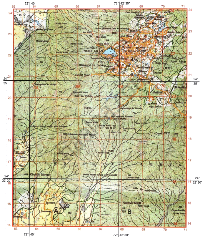
- What is RF? What is the RF given on the map extract?
- What is the four-figure grid reference of the following:
- Jain temples in the north?
- A burial ground closest to Nakhi Talao?
- Interpret the following in the four figure grids mentioned along:
- Falls 12 min 7019.
- 1327 Δ in 6721.
- What is the drainage pattern in four figure grids 6917 and in 6818 respectively?
- List two possible reasons why there isn’t direct metalled road connectivity between Abu in the north and the settlements in the southern part of the map extract.
- Give the six-figure grid reference of the following:
- Spot height 1277.
- Veterinary Hospital near Abu Town.
- What is the difference in the pattern of settlements between Abu in the north and Chandela in the south respectively?
- List any two reasons why Abu is a natural, tourism destination.
-
- What is the specialty of the well at Sakora (6317)?
- How many Tahsils or Talukas are shown on the map extract?
-
- Give one reason to say why the water of Nakhi Talao must not be used for potable purpose by the residents of Abu.
- What is the direction of Hetamiji from Nakhi Talao?
अति संक्षिप्त उत्तर
Advertisements
उत्तर
- Representative Fraction Scale It is 1 : 50000, which means one unit of distance on map represents fifty thousand similar units of distance on the ground.
-
- 6923
- 6721
-
- The relative height of the waterfall along the seasonal stream is 12 meters.
- It is a triangulated height. It shows the height of the triangulated station is 1327 meters above mean sea level.
- 6917 is a radial drainage pattern.
6818 is a dendritic drainage pattern. -
- The central region is characterised by steep mountain ridges, precipitous slopes, and hills (Ramkund ka Pahár and Kua ka Pahár), making road construction challenging.
- The presence of a large dense mixed jungle (protected and reserved forests) limits massive structural clearances in order to conserve biodiversity and natural topography.
-
- 701213 or 701212
- 687210
- Abu is a permanent nucleated/clustersed settlement.
Fatehura is a scattered, dispersed settlement. -
- It appears to be a hill station as indicated by the numerous contours surrounding it.
- Historic significance due to the presence of Cave dwellings, Dilwara temples, etc.
- Religious significance due to the presence of Jain temples, Hanumanji Ka Mandir, Shri Vashisht Ashram, etc.
- Recreational facilities such as Nakhi Talao, Sunset Point, etc.
-
- Well at Sakora (6317): It is a brackish well, i.e., a well with hard water, containing dissolved minerals and salt. Therefore, its water is unfit for drinking.
- Three
-
- The water may be polluted, as Nakhi Talao is surrounded by human habitations.
- Direction of Hetamiji from Nakhi Talao is Southeast.
shaalaa.com
या प्रश्नात किंवा उत्तरात काही त्रुटी आहे का?
