Advertisements
Advertisements
प्रश्न
Study the extract of the Survey of India map sheet no: G43510 - Map 4 and answer the following questions (Eastings 49 to 57 and Northings 13 to 23):
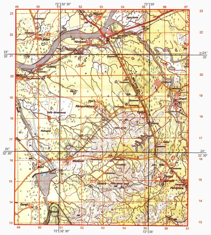
- What is the purpose of the following:
- Causeway in grid square 5619?
- Sluice in grid square 5015?
- On which bank of Sukli Nadi is village Butri situated? Give a reason for your answer.
-
- What is the height of the embankment across the river in four figure grid 5015?
- What is the nature of the canal in grid reference 49167?
- What is the drainage pattern in four figure grids 5113 and in 5117 respectively?
- What is the most important occupation shown on the map extract? Give reason for your answer.
- Identify the following:
- Broken brown lines in grid reference 5320
- Black vertical line along easting 51
- What is the area in kilometre square, depicted on the map extract?
- What is the six figure grid reference of the following:
- Dispensary at Makawal?
- Distance stone numbered 30 along the metalled road connecting Karaunti and Palrikhera?
-
- What is the social activity of the people of Marol?
- What is the direction of Makawal (5116) from Was (5615)?
- Give two man made evidences from grid square 5618 to prove that the region in the map extract receives seasonal rainfall.
कारण सांगा
सविस्तर उत्तर
Advertisements
उत्तर
-
- Causeway is used to connect the metalled road across the seasonal stream between settlements Dhavli and Devkawas.
- Sluice is used to control the flow of water to the canal.
- On left bank
Reason: Sukli Nadi flows in the northwest direction, and Butri is on the left side of Sukli Nadi. -
- The relative height of the earthen embankment is 7 meters from the ground.
- The nature of the canal in grid reference 49167 is Seasonal canal.
- 5113 is a radial drainage pattern.
5117 is a dendritic drainage pattern. - Agriculture is the most important occupation.
Reason: Presence of yellow wash which represents cultivated land. -
- Form lines
- It represents a line of longitude 72° 32'30"
- The area in square kilometers, depicted on the map extract is 80 km2.
-
- 513158
- 538207
-
- Monthly fair is the social activity of the people of Marol
- The direction of Makawal (5116) from Was (5615) is west.
-
- Presence of Causeways: The construction of causeways across streams shows that these channels dry out for the majority of the year, but require elevated road crossings during sudden monsoon floods.
- Lined Perennial Wells: Perennial wells (shown by blue circles) show that because surface river water is only available periodically, the population relies on deep underground aquifers for a constant water supply.
shaalaa.com
या प्रश्नात किंवा उत्तरात काही त्रुटी आहे का?
