Advertisements
Advertisements
प्रश्न
Study the extract of the Survey of India map sheet no: G4357 - Map 5 and answer the following questions (Eastings 24 to 32 and Northings 02 to 12):
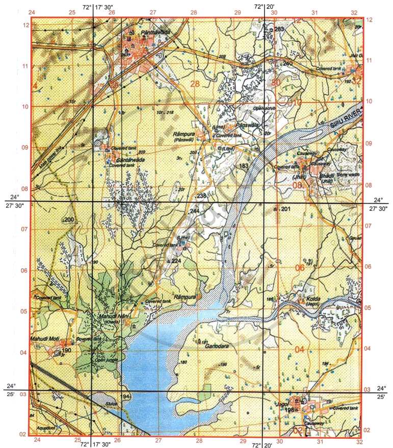
- Give the four figure grid reference of the following:
- A police station.
- Sluice
- What is the nature of Sipu River in its upper section? What is the direction of its flow in the map extract?
- What do the dark brown patches in four figure grid reference 2709 indicate?
- What is the drainage pattern in four figure grids 2806 and in 2807 respectively?
-
- What is the chief reason for the perennial nature of Sipu River to the south of Northing 057
- On which bank of Sipu River is village Rampura located?
- Interpret the following:
- Black straight line with three black dots in between in four figure grid 2411.
- Red broken lines in four figure grid reference 2906.
- Apart from its size, what else makes Panthawada more important settlement than the rest (two reasons only)?
- What is the crow-flying distance in km between triangulated heights 198 and 224?
- List two important occupations of the people living in four figure grid 2706. Give a reason each for your answer.
-
- What is the pattern of settlement at Mahudi Moti?
- Interpret the conventional symbol shown at six figure grid reference 286089?
कारण सांगा
सविस्तर उत्तर
Advertisements
उत्तर
-
- 2611
- 2502
- It is a seasonal river with a perennial waterchannel.
The river flows towards the south. - Sand dunes and Sand hills
- 2806 is Trellised. 2807 is Trellised.
-
- There is an embankment across the riverin four figure grid 2602 which impoundswater.
- Bank of village Rampura situated on the Right bank of the Sipu River.
-
- Surveyed Powerline
- Pack track
- The area is well-connected via metalled roads and cart tracks. It has an important facilities such as a police station and a post office.
- Scale: 2 cm to 1 km
Distance on map = 9.4 cm
Therefore, actual crow-flying distance = 9.4 cm × 1 km = 4.7 km -
- Agriculture: Indicated by the prominent yellow wash signifying cultivable land.
- Lime making: as the occupation isthe presence of a lime kiln.
-
- Mahudi Moti is a permanent nucleated/clustered settlement.
- A lime kiln
shaalaa.com
या प्रश्नात किंवा उत्तरात काही त्रुटी आहे का?
