Advertisements
Advertisements
प्रश्न
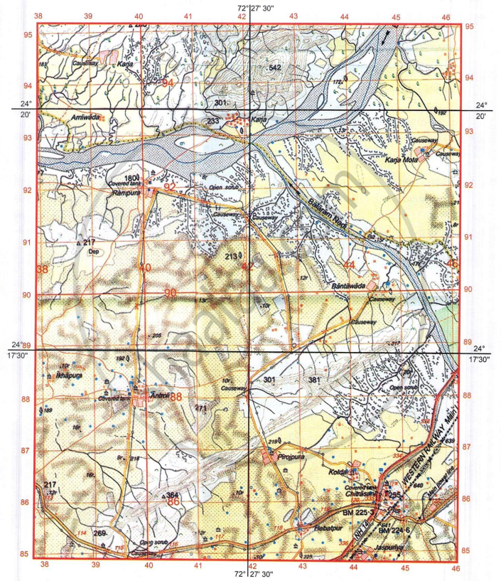
Study the extract of the Survey of India map sheet no: G43S7 - Map 1 and answer the following questions (Eastings 38 to 46, Northings 85 to 95):
-
- Give four figure grid reference for the post office in the south-east quarter of the map extract.
- What is the settlement pattern of Chitrasani?
-
- Which National Highway passes through Chitrasani?
- What is the six figure grid reference of the railway station?
- What are the two main sources of potable water in Chitrasani?
- With reference to the dark brown dots present on major parts of the map extract, what conclusions could one draw about the type of soil and climatic conditions of the region depicted?
-
- How does the metalled road cross seasonal stream in four figure grid reference 4389?
- What does number 192 in four figure grid reference 3988 represent?
- What is the direction of the flow of Balaram Nadi? On which bank of the main river does it join?
- What is the meaning of:
- 10r in 4289
- Blue line inside Banas river
- What is the drainage pattern in four figure grid references 4388 and 3986 respectively?
- What is the direction of the following:
- Antroli (4088) from Hebatpur (4385)?
- Δ 364 (4086) from Rampura (4092)?
- What is the area in km2 that lies to the south of Northing 87?
सविस्तर उत्तर
Advertisements
उत्तर
-
- 4486
- Permanent nucleated settlement/permanent clustered settlement
-
- National Highway (NH) No. 14.
- 447858
- Lined perennial wells, Covered tanks, overhead tanks
- Type of Soil: Arid/Sandy soil.
Climate: Tropical monsoon climate with seasonal, scanty rainfall/Hot and dry desert climate with seasonal, scanty rainfall. -
- The metalled road crosses the seasonal stream by a bridge.
- Surveyed tree. It shows that the height of the place is 192 m above sea level.
- Flows from Southeast to Northwest. It joins the main river (Banas river) on its Left Bank.
-
- Relative height of the sand dune/sand hillis 10 metres.
- Perennial water channel
-
- 4388: Radial drainage pattern.
- 3986: Dendritic drainage pattern.
-
- North-West
- South
- Area: 16 km2
shaalaa.com
या प्रश्नात किंवा उत्तरात काही त्रुटी आहे का?
