Advertisements
Advertisements
प्रश्न
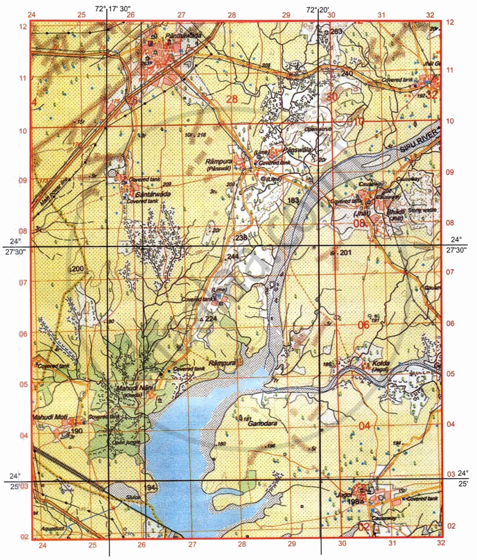
Study the extract of the Survey of India Map Sheet No: G4357 and answer the following questions:
-
- Give the four figure grid reference of Δ 224 [1]
- What is the contour interval used in the given map extract? [1]
-
- Mention two man-made features seen in grid square 2706. [1]
- Mention two natural features seen in grid square 2905. [1]
-
- What do you understand by 1:50000 printed below the map extract? [1]
- What is the pattern of drainage seen in the grid square 2505? [1]
-
- What do you understand by 10 r in 2709? [1]
- What is the compass direction of Mahudi Nani (2604) from Panswala (2909)? [1]
- Calculate the area in kilometre square of the region enclosed between Easting 26 to 29 and Northing 05 to 11? [2]
सविस्तर उत्तर
Advertisements
उत्तर
-
- 2706
- 20 metres
-
- Man-made features seen in grid square 2706 are Settlement, permanent hut, lime kiln, lined well, covered tank, powerline with poles, chattri.
- Natural features seen in grid square 2905 are Seasonal stream or dry stream, sand dunes or sand hills, broken ground, barren land, plain.
-
- It is a representative fraction. It means 1 unit on the map represents 50,000 units on the ground.
- Dendritic
-
- Relative height of the sand dunes is 10 metres.
- South West
- Area = Length × Breadth
Scale of the given map is 2 cm to 1 km.
Area = 3 × 6 = 18 grid squares
Area of 1 grid square is 1 km2
Area = 18 km2
shaalaa.com
या प्रश्नात किंवा उत्तरात काही त्रुटी आहे का?
