Advertisements
Advertisements
प्रश्न
Study the extract of the Survey of India map sheet no: G43510 - Map 8 and answer the following questions (Eastings 52 to 60 and Northings 26 to 36):
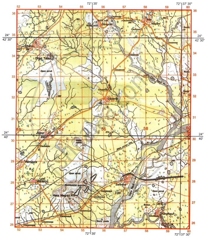
- If a man were to walk from settlement Dhann to Dadarla:
- In which direction would he be walking?
- What kind of road would he be using?
- What is the distance travelled by him (in kilometres) along the road?
-
- How are gentle and steep slopes represented in a topo map?
- What is the meaning of 14 r in four figure grid reference 5333.
- What is the difference in drainage pattern between grid references 5427 and 5434?
- Define Contour interval. What is the contour interval of the map given to you?
- Give the four figure grid reference of the following:
- Largest area under broken ground.
- Confluence of Sipu Nadi and Dior Nadi.
-
- Give two probable reasons other than dry water features, to indicate that the region depicted on the map extract receives seasonal rainfall.
- Give reason - The region between settlement Selwara and grid square 5326 has number of Causeways.
- What is the difference in settlement pattern found at Selwara and in four figure grid reference 5331 respectively?
-
- What is a Diggi (5835)?
- What is a rocky knob (5535)?
- What is the aerial distance in kilometres between the Chhatri at Dhandhpur (5826) to the temple at Dhann (5234)?
कारण सांगा
सविस्तर उत्तर
Advertisements
उत्तर
-
- South East
- Cart track
- 4 km
-
- Gentle slopes are represented by widely separated contour lines, and steep slopes are represented by closely spaced contour lines.
- Relative depth of the lined perennial well is 14 meters.
-
- 5427 is Radial drainage
- 5434 is Dendritic drainage
- The difference in height between two successive contour lines is called contour interval. The contour interval is 20 meters.
-
- 5332
- 5930
-
- Broken grounds, Causeways
- Several seasonal streams flow across the metalled road. Causeways are created to allow vehicles to travel freely on the metalled road above these streams.
- Selwara is permanent nucleated settlement.
5331 is permanent dispersed settlement. -
- Diggi - Tank used to store rain water forirrigation.
- Rocky knob -A protruding part of a rock overlooking a valley.
- 9.5 km
shaalaa.com
या प्रश्नात किंवा उत्तरात काही त्रुटी आहे का?
