Advertisements
Advertisements
प्रश्न
Study the extract of the Survey of India Map Sheet No: G4357 and answer the following questions:
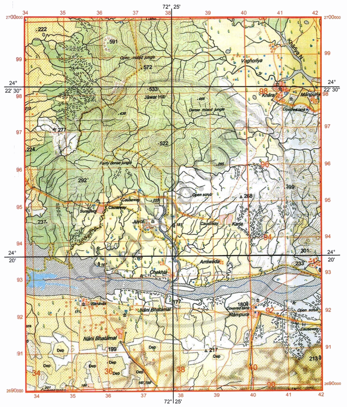
-
- Give the six-figure grid reference for spot height .522 [1]
- What is the pattern of settlement in the grid square 3591? [1]
-
- Mention two man-made features seen in the grid square 3794 [1]
- Mention two means of transport used by the people of Nani Bhatamal in the grid square 3691. [1]
-
- Identify the landform marked by the contours in the grid square 3896. [1]
- What is the pattern of drainage seen in the grid square 3697? [1]
-
- What is the reason for the presence of causeway in the grid square 3695? [1]
- What is the compass direction of Khara (4097) from Karja (3994)? [1]
- Calculate the area in kilometre square of the region to the south of 94 Northing. [2]
दीर्घउत्तर
Advertisements
उत्तर
-
- 376967/376966
- Scattered/Dispersed
-
- Man-made features seen in the grid square 3794 are Permanent hut, settlement, chatri, lined perennial well, cart track, pack tract, metalled road.
- Means of transport used by the people of Nani Bhatamal in the grid square 3691 are Cart track, pack track, metalled road.
- Hill, valley, ridge, escarpment, steep slope, conical hill/watershed) water divide, saddle
-
- Many streams are present/ Presence of seasonal minor stream.
- Northeast
- Area = Length × Breadth
Here, Area = 8 × 4 = 32 km2
In the actual council topo map it is 10 × 4 = 40 km2
shaalaa.com
या प्रश्नात किंवा उत्तरात काही त्रुटी आहे का?
