Advertisements
Advertisements
प्रश्न
What is an overlay analysis?
Answer the following question in about 30 words:
What is an overlay analysis?
Advertisements
उत्तर
Overlay Analysis Operations is the hallmark of GIS. The integration of multiple layers of maps using overlay operations is an important analysis function. In other words, GIS makes it possible to overlay two or more thematic layers of maps of the same area to obtain a new map layer, similar to sieve mapping, i.e., overlaying traced maps on a light table to make comparisons and obtain an output map.
Overlay Opeartion: x + y = z
Where,
x = Road map
y = Rail map
z = Transport map
+ = The spatial overlay operation ‘union’
Geographical representation:
 |
+ | 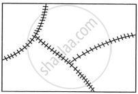 |
= | 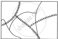 |
| Road map | Rail map | Transport map |
संबंधित प्रश्न
Urban change detection is effectively undertaken in GIS core using ______.
Answer the following question in about 125 words:
Write an explanatory account of the sequence of activities involved in GIS related work.
Make correct pairs of the following two columns and select the correct option.
| Period | Approach |
| 1. Early colonial period | (a) Exploration and Description |
| 2. Late 1950’s to the late 1960’s | (b) Regional Analysis |
| 3. Later colonial period | (c) Aerial Differentiation |
| 4. 1930’s through the inter-war period | (d) Spatial Organization |
