Advertisements
Advertisements
प्रश्न
Suppose your town, village or city has 100 people. Draw a rough map of the place on a graph paper. Imagine each square on the paper represents a specific area of the place, like residential neighbourhoods, parks, schools, factories, post offices and so on.
Now, distribute the 100 people throughout the area. You can decide where the people will live, whether they all live in the residential areas, or some live in the commercial or industrial areas. Write this number in each of the boxes.
In your depiction of the map, which areas are heavily populated and which are not? What were the reasons behind your choices of allocation of people?
कृति
Advertisements
उत्तर
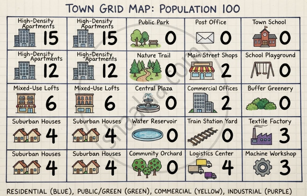
Population Density Breakdown
- Heavily Populated Areas: The Residential Zones (left columns) are the most crowded. The multi-storey high-density apartments alone house 54 people, while the entire residential sector holds 70 people.
- Lightly Populated Areas: The Commercial and Industrial Zones (right columns) are sparsely populated with 14 people total (4 in shops/offices, 10 in factories/logistics centres), representing live-in caretakers or night shifts.
- Unpopulated Areas: The Public, Green, and Institutional Zones (centre and top right) have 0 residents.
Reasons for Allocation Choices
- Efficient Land Use: Grouping 54% of the population into compact apartments leaves plenty of room for nature and shared community spaces.
- Health and Safety: Industrial zones (textile factory and machine workshop) are placed far away from housing, separated by a central green buffer to block noise and pollution.
- Convenience: Commercial shopfronts and workplaces are situated close to residential lines for easy, walkable commutes.
- Resource Protection: Keeping parks, orchards, and the water reservoir unpopulated safeguards the local water supply and ecosystem from urban waste.
shaalaa.com
क्या इस प्रश्न या उत्तर में कोई त्रुटि है?
