Advertisements
Advertisements
प्रश्न
Study the given figures and answer the following questions:
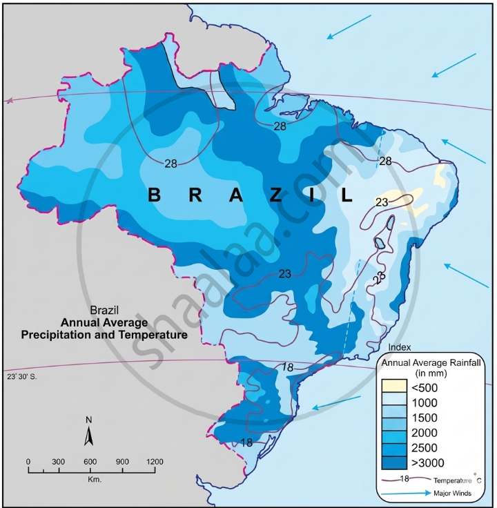
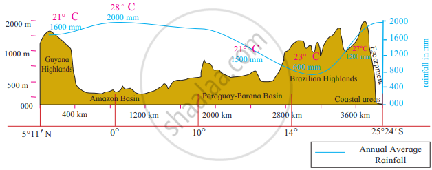
- Considering the isotherms of Brazil, what is the average range of temperature in Brazil?
- In which area does it rain more?
- From which directions are winds flowing towards Brazil?
- What could be the reason behind that?
- What could be the obstruction in the way of these winds?
- Which type of rainfall will occur because of these winds?
- Correlate these winds and rainfall.
- In which part of Brazil are the average temperatures low?
- Identify the rain-shadow area in Brazil. Describe its climatic characteristics.
- In which region do you find a higher temperature?
- Considering the latitudinal extent of Brazil, where will you find a temperate climate in Brazil?
- Describe the winds blowing between 0° to 5° N and S zones.
- Which method has been used to show distribution in this map?
Advertisements
उत्तर
- Considering the isotherms of Brazil, the average range of temperature of Brazil is 10°C (28°C-18°C).
- It rains more in the northern and central part of Brazil. E.g., Amazon Valley.
- The winds are blowing from North East and South East directions.
- These are permanent trade winds which blow from the high-pressure belt to the equatorial low-pressure belt. Brazil, being in the tropical zone, creates a low-pressure area, and winds start blowing from the ocean to the land.
- The Escarpment acts as an obstruction in the way of the South East Trade Winds coming from the sea.
- Orographic rainfall will occur because of these winds.
- The escarpments act as an obstruction to the winds blowing from the sea and cause an orographic type of rainfall in the coastal region. Beyond the Highlands, the effect of these winds gets reduced. As a result, the rainfall is minimal.
- The average temperatures are low in the southern part of Brazil.
- The north-eastern part of the Brazilian highlands is a rain shadow region. Beyond the highlands, the effect of the South East Trade Winds gets reduced and the rainfall is minimal. Also, the temperature here is quite high. This rain shadow region is referred to as the ‘Drought Quadrilateral’.
- The northern part of Brazil has higher temperatures.
- The southern part of Brazil, lying below 23° 30' S latitude (Tropic of Capricorn), experiences a temperate climate.
- The winds blowing between 0° and 5° N and S zones move vertically, leading to convectional rain. The North East and South East Trade winds are very weak in this region.
- The Isopleth method has been used to show the distribution in this map.
APPEARS IN
संबंधित प्रश्न
Give geographical reasons:
The northeastern part of the Brazilian Highlands receives very less rainfall.
Give geographical reasons:
Snowfall doesn’t always occur in Brazil.
Study the graphs given in Fig and answer the following questions.
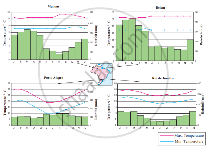
- In which month is the highest temperature found in all four cities?
- In which month does it rain the most in the given cities?
- When does Brazil have its rainy season?
- Which city has the maximum range of temperature? How much is it?
- What type of climate will be found in Rio De Janerio?
State whether right or wrong-
Location of Brazil on equator is affecting the climate of Brazil.
Write answer in one sentence-
Which type of climate is found in the south of tropic of Capricorn in Brazil?
Brazil gets rainfall from south-east and north-east ______ winds.
What is the rainshadow region in Brazil called?
Give geographical reasons.
There have been practically no instances of snowfall in Brazil.
Write about the climate variations in Brazil.
Brazil gets rainfall from the ______ and the north-east trade winds.
