Advertisements
Advertisements
प्रश्न
Explain the variations found in temperatures of Brazil according to season.
Advertisements
उत्तर १
Brazil is the world's fifth-largest country, covering 47 percent of the continent of South America. The temperature in Brazil fluctuates depending on where you are. More information on Brazil's temperature.
South Region of Brazil:
This region is known as the coldest region of Brazil where the average temperature in summer is about 22 degrees Celsius and it would increase to reach 30 degrees in the regions that are closer to the ocean. The summer is also rainy.
The winter temperature of the South region varies from 5 degrees Celsius to zero degrees Celsius.
Southeast Region:
This is the region that homes two important cities Rio de Janeiro and Sao Paulo. The temperature varies from 30 degrees to 25 degrees Celsius in summer and 18 to 10 degrees in winter.
Central West region:
This region is a mix of the South and Southeast regions. The average temperature in summer is 35 degrees Celsius and 20 degrees in winter.
Northeast region:
This is the hottest region of Brazil and suffers from water scarcity. The average temperature in summer is 38 degrees Celsius and 21 degrees Celsius in winter.
North Region:
This is where the Amazon forest lies. This region is found mostly rainy and the temperature in summer is 27 degrees Celsius.
उत्तर २
Points - location of Brazil- latitudinal extent high – variation found
in climate
- north- near equator – equable climate throughout the year
- coastal areas equable
- south is comparatively cooler and the northern part near
Guyana highland experiences high temperatures.
APPEARS IN
संबंधित प्रश्न
Select the correct option and rewrite the sentence:
As the ---------------- extent of Brazil is more, there is a variety in climatic conditions.
Answer the following question in detail:
Write the factors affecting climate of Brazil.
State whether right or wrong. Rewrite the wrong sentence.
Brazil gets a lot of rainfall because of the southwest monsoon winds.
Discuss the factors affecting the climate of Brazil.
Study the graphs given in Fig and answer the following questions.
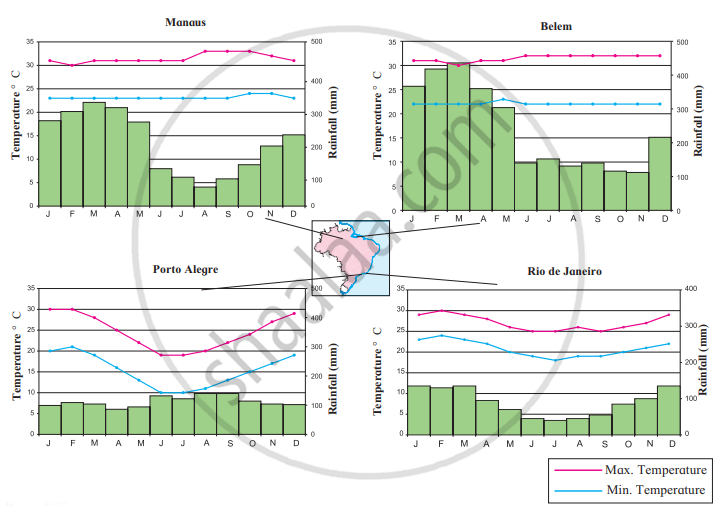
- In which month is the highest temperature found in all four cities?
- In which month does it rain the most in the given cities?
- When does Brazil have its rainy season?
- Which city has the maximum range of temperature? How much is it?
- What type of climate will be found in Rio De Janerio?
Considering the location, the extent of Brazil and India, look for the differences in the elements of climate like temperature and rainfall as per direction. Write a short note on it.
State whether right or wrong-
Location of Brazil on equator is affecting the climate of Brazil.
Give geographical reasons.
There have been practically no instances of snowfall in Brazil.
Write about the climate variations in Brazil.
Brazil gets rainfall from the ______ and the north-east trade winds.
