Advertisements
Advertisements
प्रश्न
Distinguish between:
Climate of India and the climate of Brazil
Advertisements
उत्तर
| Climate of India | Climate of Brazil | |
| 1. | India has a monsoon-type climate. | Brazil experiences a wide range of variations in climate. For example, the climate is hot near the equator while it is temperate near the Tropic of Capricorn. |
| 2. | In India, the average temperature is higher throughout the year since the sun’s rays are perpendicular up to the Tropic of Cancer, which passes through it. | In Brazil, the equator cuts across the northern part of the country which results in 25° C to 28° C of average temperature in the Amazon Valley. |
| 3. | The temperature in the northern states of India is cold. The temperature increases towards the southern states. | The northern part of Brazil is generally hot, while in the southern part, the temperature is comparatively lower. |
| 4. | India receives rainfall due to the South-west monsoon winds, and the rainfall is mainly of orographic rain. | Brazil receives orographic type of rainfall from the South-east Trade winds & North-east Trade winds, and the rainfall in the northern part of Brazil is of convectional type. |
| 5. | Tropical cyclones occur frequently in India. | Tropical cyclones occur rarely in Brazil. |
संबंधित प्रश्न
Choose the right answer from the alternative given below.
Which one of the following causes rainfall during winters in north-western part of India?
These forests are found along the rivers on Khadar areas:
Match the following.
| 1. | Manas | Jammu & Kashmir |
| 2. | Madumalai | Jharkhand |
| 3. | Duchigam | Assam |
| 4. | Hazari Bagh | Rajasthan |
| 5. | Sarika | Tamil Nadu |
Match the following.
| 1. | Rubber and Mahogany | Western Himalayas |
| 2. | Sandwood and rosewood | Eastern Himalayan Forest |
| 3. | Oak, birch, Silver | Coastal forest |
| 4. | Casurina, Palm and coconut | Deciduous forest |
| 5. | Sal, Semal, Jamun and Jujube | Evergreen forest |
Match the Column I with Column II.
| Column I | Column II | |
| A. | Tropical evergreen forest | Sandal wood |
| B. | Tropical Deciduous forest | Oak, silver fir |
| C. | Alpine forest | Black buck |
| D. | Tidal forest | Casuarina |
| E. | Coastal forest | Mahogany |
| F. | State animal of Andhra Pradesh, Pujab and Haryana | Mangrove trees |
Equable climate is also called as the ______.
Which part of India experiences the highest range of temperature in a day?
Why does the coromandal coast face frequent cyclones?
Find out which songs, dances, festivals and special food preparations are associated with certain seasons in your region. Do they have some commonality with other regions of India?
Observe the following graph and answer the questions given below:
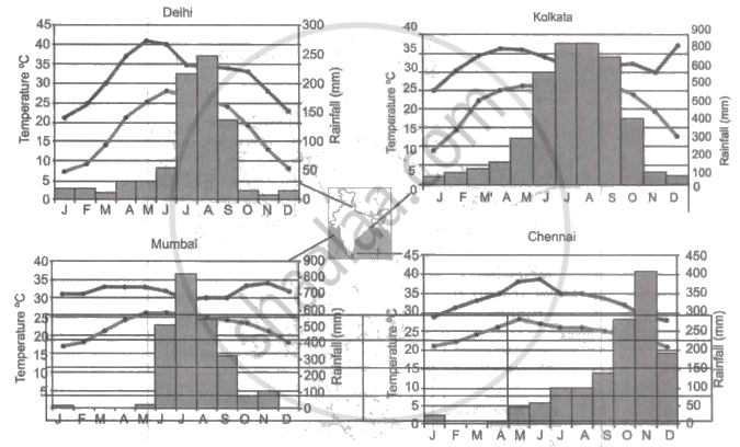
Note: In the graphs, the dark line represents the max. temperature and the lighter line represents min. temperature. The bars represent the amount of rainfall every month in each city.
- Where in the four cities is the rainfall heaviest?
- Which city has the most rainfall throughout the year?
- Which city experiences the highest temperature?
- Calculate the average range of minimum and maximum temperature for all four cities.
- What do the temperature curves in Delhi indicate?
- What is the condition of Mumbai during monsoons?
