Please select a subject first
Advertisements
Advertisements
Is this sentence right or wrong? Rewrite the wrong ones.
Equator passes through the northern part of Brazil.
Concept: Brazil - Location, Size and Extent
How are Brazil and India different from each other in terms of location?
Concept: Brazil - Location, Size and Extent
Which of the following shapes shows the coastal part of Brazil correctly?
Concept: Brazil - Location, Size and Extent
The imperial power which ruled Brazil also ruled a part of India. Find out when that part of India achieved independence?
Concept: Historical Background of India
Write a short note.
Historical background of India.
Concept: Historical Background of India
Read the following map and answer the questions given below.
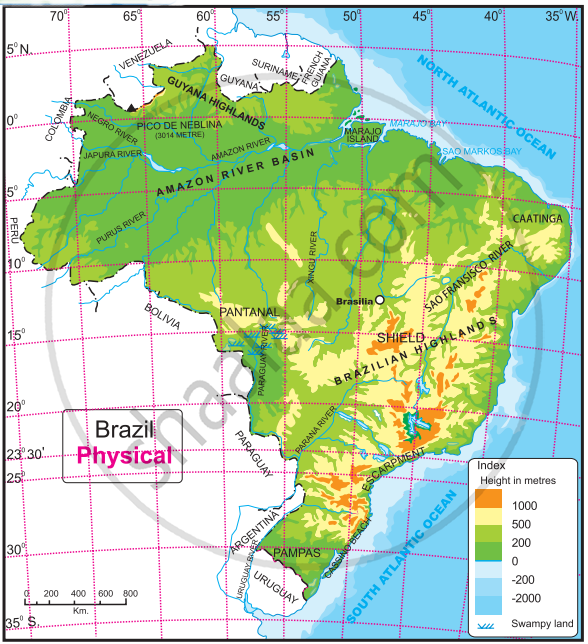
Questions-
- What is the range of the altitude of Amazon river basin?
- Between which two highlands is the Amazon river basin located?
- Write the height of the peak ‘Pico de Neblina’.
- Caatinga area is found at which direction of Brazil?
- Which grassland is located at south of Brazil?
Concept: Brazil - Location, Size and Extent
Show the following in the outline map of India with index.
- Thar desert
- Ladakh
- 0-20% urbanization state at the east of India
- Apple producing state at north most of India
- Chennai port
- Kanyakumari-a tourist centre
Concept: Indian - Location, Size and Extent
Show the following in the outline map of Brazil with index.
- Condor
- The northernmost state of Brazil with less population density
- The southernmost state of Brazil which produces soyabean
- Victoria port
- Rio de Janerio-a tourist place
- Brasilia airport
Concept: Brazil - Location, Size and Extent
Explain the historical background of Brazil.
Concept: Historical Background of India
India is located in the ______ hemispheres of the earth.
Concept: Indian - Location, Size and Extent
Which is the popular sport of Brazil ?
Concept: Indian - Location, Size and Extent
Areawise which is the largest state in India?
Concept: Historical Background of India
Brazil was under the control of the ______.
Concept: Historical Background of Brazil
Mark the following in the outline map of India. Write the names and give the index.

- Indira Point
- River Ganga
- Chhota Nagpur Plateau
- Mawsynram
- High Population Zone
- Andaman and Nicobar Islands
Concept: Indian - Location, Size and Extent
Observe the map of Brazil and answer the following questions.

- Name the only port which may be considered inland.
- What are the modes of transport available from Brasilia?
- Name two tourist places with an airport and a port.
- What is the relative position of Cuiaba with respect to Brasilia?
- How can you reach Brasilia from Rio de Janeiro?
- Which is the tourist location in the extreme west?
Concept: Brazil - Location, Size and Extent
Highlight the historical background of India and Brazil.
Concept: Historical Background of India
Indira Point is located on ______ N parallel.
Concept: Indian - Location, Size and Extent
Answer in one sentence.
Name the imaginary line that passes through the northern part of Brazil.
Concept: Historical Background of Brazil
Write a short note.
Historical background of Brazil
Concept: Historical Background of Brazil
The Western Himalayas
Concept: Physical Division of India> The Himalayas
