HSC Arts (English Medium)
Academic Year: 2025-2026
Date & Time: 7th March 2026, 3:00 pm
Duration: 3h
Advertisements
Note:
- All questions are compulsory.
- Draw relevant diagrams/graphs wherever necessary.
- Use of colour pencil is allowed.
- Use of map stencil is allowed.
- Figures to the right indicate full marks.
- Tie your supplement of map to your main answer sheet.
Complete the chain according to the co-relation of factors in column ‘A’ ‘B’ and ‘C’:
| No. | ‘A’ | ‘B’ | ‘C’ |
| (1) | Making maps | (a) Delhi | (l) Niger |
| (2) | Administrative cities | (b) Pampas | (m) Small-Scale Industry |
| (3) | Grass-Land Region | (c) Observation | (n) Skills of Geographer |
| (4) | Toys | (d) Bangladesh | (o) New York |
| (5) | Population Explosion | (e) Paper industry | (p) Argentina |
Chapter:
Tertiary activities include ______.
Fishing
Sugar Industry
Animal Husbandry
Trade
Chapter:
Human factors affecting the distribution of population -
Climate
Soils
Transportation
Relief
Chapter:
A major crop of extensive commercial agriculture -
coffee
wheat
rice
medicinal plants
Chapter:
Functional region -
Pune Metropolitan
Latur
Satara
Amravati
Chapter:
Bharat Heavy Electricals Limited is ______ type of establishment.
Joint Sector
Co-operative Sector
Public Sector
Private Sector
Chapter:
Arrange the following industries in descending order based on capital investments -
- Small scale industry
- Micro scale industry
- Large scale industry
- Medium scale industry
Chapter:
Identify the incorrect factor -
Research
Training
Hunting
Teaching
Chapter:
Arrange the countries on the basis of their location from West to East -
- France
- India
- Japan
- U.S.A.
Chapter:
Identify a country passing through the ‘late expanding stage’ of Demographic Transition Model/Theory-
Germany
Sweden
Congo
China
Chapter:
Ideal location for fishing fields -
Rugged coasts, shallow seas, hot climate, growth of planktons.
Shallow seas, confluence of warm and cold ocean currents, growth of planktons, cold climate.
Continental shelf, growth of planktons, good skill of fishing, warm climate.
Continental shell, broken coasts, growth of planktons, warm climate.
Chapter:
Write True or False:
Economic Geography is a branch of Human Geography.
Chapter:
Write True or False:
Migration is not a component of population change.
Chapter:
Advertisements
Write True or False:
The area between urban and rural area is called urban rural fringe.
Chapter:
Write True or False:
Various physical and human factors influence the development of agriculture.
Chapter:
Write True or False:
Factors affecting industrial location are the same everywhere.
Chapter:
Give geographical reasons:
Fruit-processing industries are found in Ratnagiri and Sindhudurg districts of Konkan region.
Chapter: [5] Secondary Economic Activities
Give geographical reasons:
Himalaya mountain region have low population.
Chapter:
Give geographical reasons:
Regional development is dependent on physical setting.
Chapter: [7] Region and Regional Development
Give geographical reasons:
Literacy rate of a country is an indicator of its socio-economic development.
Chapter: [2] Population : Part - 2
Give geographical reasons:
Not all rural settlements change into urban settlements.
Chapter: [3] Human Settlements and Land Use
Give geographical reasons:
Geographical diversity is responsible for trade to occur.
Chapter:
Differentiate between donor region and recipient region.
Chapter: [2] Population : Part - 2
Differentiate between shifting agriculture and plantation agriculture.
Chapter:
Differentiate between physical geography and human geography.
Chapter: [8] Geography : Nature and Scope
Differentiate between formal regions and functional regions.
Chapter: [7] Region and Regional Development
Advertisements
Mark and name the following on the outline map of the world with suitable index:
- Most populated city in India
- The country having highest sex-ratio in the world
- Grand Bank fishing area
- Lumbering area of Canada
- Any one industrial region in Japan
- Oil producing country in South America
- Major port in South Africa
- Trans Australian Railway route
Chapter:
Observe the pie-chart and answer the following:
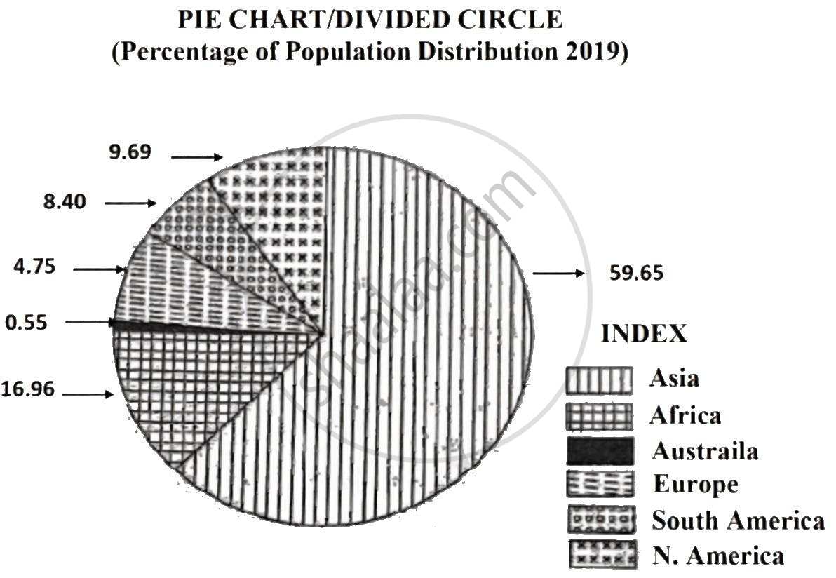
Questions:
- Which continent has the highest population?
- Which continent has 9.69 percent of total population of the world?
- Which continent has the least population?
- How many percent of population is in Europe?
- Which continent is missing in this pie-chart? Why?
Chapter:
Write a note on the following:
Reasons for migration.
Chapter:
Write a note on the following:
Factors affecting regional imbalance in India.
Chapter:
Write a short note on the correlation between birth rates and death rates.
Chapter:
Write a note on the following:
Means of communication.
Chapter:
Write a short note on the following:
Nature of Geography.
Chapter:
Read the following passage and answer the questions given below:
|
More than 3,500 years back, the city of Knossos on the island of Crete was the main centre town of the Minuan civilization. By 500 BC, Greece had become one of the most highly urbanized areas on the Earth. The Greeks established over 500 cities and small towns on the main lands as well as on the islands. Athens and Sparta were the leading cities of Greece. Athens may have been the largest city in the world at the time, with an estimated 2,50,000 inhabitants. The Greek cities were the centres of religion and power but also served as economic nodes. Cities were the main market places and bases from which wealthy merchants, land and livestock owners and traders operated. As educational centres, residents of cities included teachers and philosophers. They also had handicrafts industries that attracted the best crafts people and investors. In all of these roles, ancient cities were the anchors of cultural society; the focal points of power, authority and change. |
Questions:
- Which was the largest city in the world during Greek period?
- State the role of Greek cities.
- What was the estimated population of Athens city?
- Which amenities and services were available in ancient Greek cities?
Chapter:
Draw a diagram and label it:
Linear settlement
Chapter: [1] Population : Part - 1
Draw a neat and labelled diagram:
Provision of public goods and services to minimize regional imbalance.
Chapter:
Draw a neat, labelled diagram:
Branches of Human Geography
Chapter:
Explain the characteristics of extensive commercial grain farming with its distribution.
Chapter:
Explain any five factors affecting the location of industries in India.
Chapter:
Other Solutions
Submit Question Paper
Help us maintain new question papers on Shaalaa.com, so we can continue to help studentsonly jpg, png and pdf files
Maharashtra State Board previous year question papers 12th Standard Board Exam Geography with solutions 2025 - 2026
Previous year Question paper for Maharashtra State Board 12th Standard Board Exam Geography-2026 is solved by experts. Solved question papers gives you the chance to check yourself after your mock test.
By referring the question paper Solutions for Geography, you can scale your preparation level and work on your weak areas. It will also help the candidates in developing the time-management skills. Practice makes perfect, and there is no better way to practice than to attempt previous year question paper solutions of Maharashtra State Board 12th Standard Board Exam.
How Maharashtra State Board 12th Standard Board Exam Question Paper solutions Help Students ?
• Question paper solutions for Geography will helps students to prepare for exam.
• Question paper with answer will boost students confidence in exam time and also give you an idea About the important questions and topics to be prepared for the board exam.
• For finding solution of question papers no need to refer so multiple sources like textbook or guides.
