Advertisements
Advertisements
प्रश्न
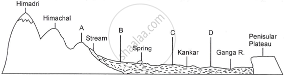
The figure below represents a topographic section from the Himalayas to the Peninsular region. Identify any two of the features marked A, B, C and D.
लघु उत्तर
Advertisements
उत्तर
- Shivaliks (or Outer Himalayas): The outermost range of the Himalayas.
- Bhabar: The area formed by pebbly alluvium, located along the foot of the Shivalik hills.
- Bhangar: The old alluvial region above the floodplain, typically containing calcareous deposits (known as kankar).
- Khadar: The newer and fertile alluvial plain, typically found along the riverbed and easily flooded.
shaalaa.com
Geological Formation
या प्रश्नात किंवा उत्तरात काही त्रुटी आहे का?
