Advertisements
Advertisements
प्रश्न
Study the outline map of India given below and answer the questions that follow:
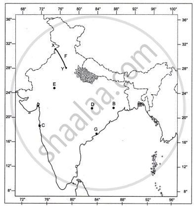
- The state shaded and marked A that cultivates wheat is ______. [1]
- The centre marked B that produces iron ore is ______. [1]
- The city marked C that has the largest number of cotton textile industries in India, is ______. [1]
- Identify and name the following:
- The centrally located iron and steel plant of India marked D. [1]
- The centre for the nuclear power plant marked E. [1]
- The roadway marked F, connecting the two cities marked X and Y is ______. [1]
- North South corridor
- East West corridor
- National Highway 1
- National Highway 2
- The port city marked G is ______. [1]
- New Mangalore
- Vishakhapatnam
- Marmagao
- Haldia
रिकाम्या जागा भरा
Advertisements
उत्तर
- The state shaded and marked A that cultivates wheat is Uttar Pradesh.
- The centre marked B that produces iron ore is Mayurbhanj.
- The city marked C that has the largest number of cotton textile industries in India is Mumbai.
- Bhilai Steel Plant
- Rawatbhata
- The roadway marked F, connecting the two cities marked X and Y is national highway 1.
- The port city marked G is vishakhapatnam.
shaalaa.com
या प्रश्नात किंवा उत्तरात काही त्रुटी आहे का?
