Advertisements
Advertisements
प्रश्न
Study the extract of the Survey of India Map Sheet No. G43S10 Map 5 and answer the following questions [Eastings 60-70, Northings 26-36]:
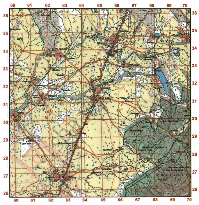
- Give the four-figure grid reference of
- Anadra Police Chauki
- Annual Fair grounds at Malgaon
- The temple at Pithapura
- The settlement at Hathal
- Give the six-figure grid reference of
- the dry tank with embankment (6r) near the fire line.
- the highest point in the extract
- the veterinary hospital at Anadra
-
- State the compass direction of Udwariya from Gulabganj.
- Mention one striking difference between these two settlements.
- Which type of road connects Anjini Devi ka Mandir till the boundary of forest? Give the four-figure grid reference where this type of road is also found. How far this temple from Moti Talao?
- Find the direct distance in km between the metalled road from NH-168 grid square 6432 and the Post Office in grid square 6233.
- What is the general direction of the flow of Sipu Nadi in the given map extract? What is the white patch (in grid square 6632) in its river bed?
- ‘Anadra is better developed settlement than Gulabganj’. Give two reasons to support your answer.
- On which bank of Sipu Nadi is the Gulabganj situated? From where does Gulabganj get its supply of water?
- State the difference in contour lines in grid squares 6726 and 6826. What does this difference show?
- In what way does the pattern of drainage in grid square 6728 differ from that in grid square 6034?
- Which settlement is better developed than other settlements in the given map extract? Give reasons to support your answer.
- What is meant by the term Fire Line? Account for the necessity of fire lines in the jungle area of the given map extract.
- Give the meaning of the following:
- 3r in grid square 6227
- •437 in grid square 6729.
- What main purpose is served by most of the wells in grid square 6232?
- What is a Diggi? Give the four figure references of any two in the extract.
- Madhav stays near Anadra. His cow is sick so he goes to the veterinary hospital at Anadra. He is told that the medical team have gone to the hospital south of Wahan. How much distance does he need to travel to get medical aid for his cow?
- Arjun is visiting his grandmother at Sirori after 20 years. List any two signs to show that the settlement has progressed.
- Write a note on the drainage pattern in the extract.
- Meena wants to attend the Annual Fairs. When and where should she visit to do so? How much distance would she have to travel between the two settlements?
- What conditions at a settlement would be conducive for the setting up of Ayurvedic medical facilities?
कारण सांगा
टीपा लिहा
सविस्तर उत्तर
Advertisements
उत्तर
-
- 6226
- 6131
- 6633
- 6030
-
- 683276
- 693252
- 627265
-
- North-east
- Udwaria is a linear settlement whereas Gulabganj is nucleated settlement.
- Unmettaled road, 6827, 6727, 6628. This temple is 6 km far from Moti Talao. Direct distance is 4.5 cm.
- 2 cm = 1 km
1 cm = `1/2` km
4.5 cm = `1/2` × 4.5
= 2 km 250 m - The direction of Sipu Nadi is towards North-west. The white patch in grid square are 6632 in the river bed is Island.
- It has both Veterinary hospital, post of office, police chauki and hospital.
- Gulabganj is situated on the left bank of Sipu Nadi. This village gets its supply of water throughout the year from perennial lined wells.
- Contour lines in 6726 indicates Gentle slope. Contour lines in 6826 indicates Steep slope.
- Drainage pattern: 6728 - Radial
- Anadra is better developed as it has police chaunki, post office, Veterinary and hospital, national highway, cicuit house, diggi etc.
- Fireline is a 5m wide pathway in the middle of the forest in order to prevent the spreading of fire. Account for the necessity of fire line in the jungle area is to prevent the spreading of fire.
-
- Relative height of dry tank with embankment is 3 m.
- The height of the land above mean sea level is 437 m.
- It is the main source of irrigation in such areas but the wells present in 6232 is brackish that is salty in nature. So, unfit for agriculture, human and animals.
- It is the small pond used for storing water. Four figure reference: 6226, 6533.
- 8 km 650 m
- It has National highway 168. It has post office and temple.
- The majority areas in toposheet experiences the Radial drainage pattern. Contours are almost circular in shape and streams flow outward forming a pattern like the spokes of a wheel.
- She need to travel from the settlement Malgaon to the settlement Pamera in the month of March.
- Anadra is the most developed settlement, due to which it makes conducive condition to have Ayurvedic hospital.
shaalaa.com
या प्रश्नात किंवा उत्तरात काही त्रुटी आहे का?
