Advertisements
Advertisements
प्रश्न
Study the extract of the Survey of India Map Sheet No. G43S10 Map 4 and answer the following questions [Eastings 47-57, Northings 24-34]:
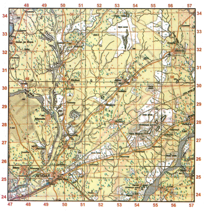
- Give the four-figure grid reference of
- the settlement of Dadarla
- Δ413
- Dispensary
- Bhamra
- Give the six-figure grid reference of
- the temple at Malawa.
- the temple at Sapol.
- the Brick Kiln at Serua.
- the surveyed tree North-East of Bhamra
- Give the compass direction of
- Revdar from Jolpur
- Rampura from Malawa
- Warka from Bhamra
- Derol from Rannari
- What are the following:
- •348 in grid square 4733.
- 6r in grid square 4828.
- 3r in grid 5630
- 286 in grid 5132
- Measure the distance in km of the unmetalled road from grid square 5031 to grid square 5233.
- What is the general pattern of drainage in the given map extract? Where is this kind of pattern usually found?
- What is the nature of streams and tanks spread over the region in the given map extract? What does the broken ground along the banks of the streams indicate?
- What is the principal means of irrigation used in the region in the given map extract? Draw the conventional symbol used for it on the maр.
- Explain the meaning of the following:
- Marblestone quarries.
- Brick

- Write a short note on the settlement Jolpur.
- Calculate the distance in km of the metalled road from Warka that intersects another metalled road in grid square 5326.
- Besides agriculture, state other probable occupations followed by people in Revdar.
- Calculate the area of the region enclosed within Eastings 47 to 50 and Northings 27 to 30.
- Name one man-made feature in grid square 5333 and one natural feature in grid square 4932.
- Name two features which make Revdar an important settlement in the given map extract.
- State any four probable occupations followed by the people of the region in the given map extract.
- What type of road exists between Malawa and Rampura? Is there an alternate route? Which route would you take?
- What is the R.F. of this map? What does it mean?
- List two occupations of the people at Serua.
- You are staying at PWD guest house at Revdar. How much distance would you travel by road to visit the temple of your family deity at the grid 4727?
स्पष्ट करा
सविस्तर उत्तर
Advertisements
उत्तर
-
- 5631
- 5427
- 4924
- 5032
-
- 501303
- 569254
- 544244
- 519327
-
- South west
- South east
- South east
- East
-
- height of the land above mean sea level is 348 m.
- Relative height of the sand dune is 6 m.
- Relative height of dry tank with embankment is 3 m.
- Surveyed tree.
- 2 km 400 m
- The general pattern of the drainage is dendritic. It is found in areas where the rocks beneath the stream has no particular structure and can be eroded easily.
- The streams and tank in the area are non-perennial with dry beds. The broken ground along the bank indicates highly eroded area, caused by alternative dry and wet periods.
- The principal means of irrigation in the given map is lined perennial well. The conventional symbol used is small blue colour dot.
-
- It is pit from which marble is obtained for different purposes.
- It is a large outdoor oven for drying and baking bricks.
- Jolpur is the nucleated settlement. It is well connected with cart track. It has unsurveyed power line and temple.
- 2 km
- People are working PWD, hospital, post office.
- No. of Easting = 3
No. of Northing = 3
Area = 3 × 3
= 9 sq.km - Man-made feature in 5333 is cart track. Natural feature in 4932 is Broken Ground.
- Man-made feature in 5333 is cart track. Natural feature in 4932 is Broken Ground.
-
- Agriculture
- Cattle Rearing
- Baking of lined stones on bricks
- Trade
- Cart track. Yes, there is an alternatively route. I will take the direct shortest route between Malawa and Rampura.
- The R.F. of the map is 1:50,000. It means 1 unit on the map represents 50,000 units on the ground.
-
- Limestone quarry
- Brick Kiln
- 3 km 600 m
shaalaa.com
या प्रश्नात किंवा उत्तरात काही त्रुटी आहे का?
