Advertisements
Advertisements
प्रश्न
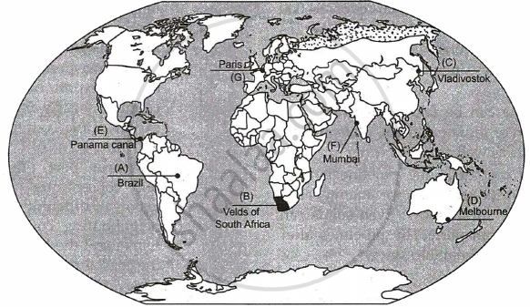
On the given political outline map of the world seven geographical features have been marked as A, B, C, D, E, F and G. Identify any five of them with the help of the following information and write their correct names on the lines drawn near them:
- The largest country of South America
- An area of extensive commercial farming
- Easternmost station of Trans-Siberian Railway'.
- A major sea-port
- The shipping canal
- An international airport of Asia
- An international airport of Europe

Advertisements
उत्तर
APPEARS IN
संबंधित प्रश्न
Name the city which has the oldest artificial harbor on the east coast of India.
The Big Trunk Route runs through ______.
When was the Suez canal constructed?
Name the seas linked by the Suez canal.
Which sea route has reduced the distance between Europe and Asia?
Which canal has reduced the distance between New York and San Francisco?
What is the objective of under construction Pan-American highway?
Write a note on the Volga waterway.
Why is the North Atlantic sea route significant?
Write a note on the Mediterranean-Indian ocean sea route.
Which canal has shortened the distance between Europe and Asia? Give five points on the canal.
Which canal has shortened the distance between the eastern and western coasts of North America? What is its economic significance?
Which is the most heavily used inland waterways in the world? Why is it important?
Name the inland waterway of Europe that connects Rotterdam and Basel.
Give the significance of the river St. Lawrence as an inland waterway.
Write any four characteristics of this canal.
Which is the busiest sea route in the world?
What is the length of inland waterways in India?
Which is the busiest sea route in the world?
The area from which rainfall flows into a river, lake, or reservoir is called a ______.
Attaining Sustainable development in the command area requires major thrust upon the measures to achieve ecological sustainability. Highlight the measures proposed to promote sustainable development in the command area of Indira Gandhi Rajasthan Canal.
After the construction of which of these canals, the travelling time between Mediterranean sea and Indian ocean has been greatly reduced?
On the given political map of the world, the following seven features are shown. Identify any five of these features and write their correct names on the lines marked near each feature.
- A Shipping Canal
- An International Airport
- An International Seaport
- An area of Extensive Commercial Grain farming
- A Nomadic Herding area
- Largest Country of South America
- A Major Seaport
Explain the importance of waterways as a mode of transportation.
Mention the important features of 'the Great Lakes - St. Lawrence Seaway'.
Study the given picture and answer the questions that follow:

- Name the waterway give in the picture.
- Name the two sea connected by this waterway.
- Name the ports marked as 'A' & 'B' in this picture.
On the given political outline map of the world seven geographical features have been marked as A, B, C, D, E, F and G. Identify any five and names them on the lines marked near them:
- An International Airport in Asia.
- A canal linking Red sea with Mediterranean sea.
- A major seaport in North America.
- A terminal station on the Trans-Australian Railway.
- A major area of nomadic herding in Africa.
- A major area of extensive commercial grain farming.
- International airport of Europe.

