Advertisements
Advertisements
प्रश्न
Now find out
Why are Tiruvanantapuram and Shillong rainier in June than in July?
Advertisements
उत्तर
The south-west monsoons hit Tiruvanantapuram and Shillong around the first of June. Thiruvananthapuram receives rain from the Arabian Sea branch while Shillong receives rain from the Bay of Bengal branch. After causing rains in these regions, these two branches keep moving on to the other parts of the country (the Arabian Sea Branch moves from south-west to north-east, while the Bay of Bengal branch moves from north-east to north-west). As a result, these regions receive lesser rainfall in the months succeeding June.
APPEARS IN
संबंधित प्रश्न
Name a state that is the first to experience the onset of the monsoon.
Name an area in India where Tropical Monsoon forest is found.
Name the following: The local wind that brings a light rainfall to South India and is good for tea and
coffee crops.
Study the data of distribution of temperature and rain for Station X and answer the questions that follow :
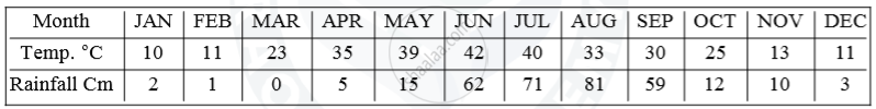
(i) Is Station X in the coastal area or in the interior of the country?
(ii) Calculate the total annual rainfall for Station X.
(iii) Name the wind that brings most of the rainfall to Station X.
How are the sources of rainfall in the North-west part of India different from the rainfall experienced on the coastal areas of Eastern India in winter?
Why does the Tamil Nadu coast get rainfall in October?
Western coastal plains receive more rainfall than the Eastern coastal plains.
Name the winds which are responsible for heavy rainfall in India.
Write a note on the uneven distribution of rainfall in India.
What is the source of winter rainfall in Punjab?
