Commerce (English Medium)
Science (English Medium)
Arts (English Medium)
Academic Year: 2025-2026
Date & Time: 26th February 2026, 10:30 am
Duration: 3h
Advertisements
General Instructions:
Read the following instructions carefully and follow them:
- This question paper contains 30 questions. All questions are compulsory.
- Question paper is divided into five Sections - Section A, B, C, D and E.
- Section A - Question Nos. 1 to 17 are Multiple Choice (MCQ) type questions. Each question carries 1 mark.
- Section B - Question Nos. 18 and 19 are source based questions. Each question carries 3 marks.
- Section C - Question Nos. 20 to 23 are Short Answer (SA) type questions. Each question carries 3 marks. Answer to these questions shall be written in 80 to 100 words.
- Section D - Question Nos. 24 to 28 are Long Answer (LA) type questions. Each question carries 5 marks. Answer to these questions shall be written in 120 to 150 words.
- Section E - Question Nos. 29 & 30 are Map based questions. Each question carries 5 marks.
- In addition to this, NOTE that a separate question has been provided for Visually Impaired Candidates in lieu of questions having visual inputs, map etc. Such questions are to be attempted by Visually Impaired Candidates only.
- There is no overall choice given in the question paper. However, an internal choice has been provided in a few questions.
Match Column - I with Column - II and choose the correct option:
| Column - I (Mineral) |
Column - II (Major Mines) |
| a. Iron-ore | i. Katni |
| b. Manganese | ii. Bhilwara |
| c. Bauxite | iii. Chandrapur |
| d. Copper | iv. Sundargarh |
a - iv, b - iii, c - i, d - ii
a - iii, b - iv, c - ii, d - i
a - iii, b - iv, c - i, d - ii
a - iv, b - iii, c - ii, d - i
Chapter:
The concept, ‘understanding the parts in totality would lead to understanding of the whole’ is concerned with which one of the following approaches of geography?
Regional analysis
Spatial organisation
Areal differentiation
Exploration and description
Chapter:
Read the information given in the box carefully and identify the mineral:
|
Copper
Mica
Bauxite
Manganese
Chapter:
Which one of the following is the least labour intensive cultivation methods?
Plantation agriculture
Subsistence agriculture
Extensive commercial cultivation
Market Gardening and Horticulture
Chapter:
Foot-loose industries are located ______
where energy supply is continuous.
where good accessibility by rail/road is available.
where cheap and skilled labour is available.
where market facilities are available.
Chapter:
Assertion (A): The economic development of a region depends upon its resource base.
Reason (R): Sometimes resource rich region remain backward.
Both (A) and (R) are true and (R) is the correct explanation of (A).
Both (A) and (R) are true but (R) is not the correct explanation of (A).
(A) is incorrect but (R) is correct.
(A) is correct but (R) is incorrect.
Chapter:
Which one of the following inland waterway and its stretch is correctly matched?
National Waterways No. 1 - Allahabad - Haldia
National Waterways No. 3 - Sadiya - Dhubri
National Waterways No. 2 - Kottapuram - Kollam
National Waterways No. 5 - Kakinada – Puducherry
Chapter:
The main Indira Gandhi Canal terminates in which one of the following districts of Rajasthan?
Bikaner
Barmer
Ganganagar
Jaisalmer
Chapter:
Assertion (A): There is a strong dichotomy between physical elements and human beings.
Reason (R): Nature and human are intricately interwined.
Both (A) and (R) are true and (R) is the correct explanation of (A).
Both (A) and (R) are true but (R) is not the correct explanation of (A).
(A) is incorrect but (R) is correct.
(A) is correct but (R) is incorrect.
Chapter:
Read the following sub-fields of social geography carefully and choose the correct option:
- Resource Geography
- Leisure Geography
- Gender Geography
- Marketing Geography
I and III are correct.
I and IV are correct.
II and III are correct.
II and IV are correct.
Chapter:
Arrange the following coal mining areas of India from south to north direction of their location and choose the correct option:
- Singareni
- Neyveli
- Jharia
- Talchar
II, I, III, IV
II, I, IV, III
I, II, IV, III
I, II, III, IV
Chapter:
Which one of the following ports is situated at ‘Zuari Estuary’?
New Mangalore
Kochchi
Marmagao
Ennore
Chapter:
Which one of the following organisations regulate the air traffic of major airports of India?
Airport Authority of India
Indian Airport Commission
Indian Air Control Board
Airport Development Authority
Chapter:
Advertisements
Which one of the following contributes maximum in India’s export?
Agriculture and allied products
Ores and minerals
Manufactured goods
Mineral fuels and lubricants
Chapter:
Study the following table carefully and answer the question.
| Human Development Index 2022 | ||
| S. N. | Country | HDI Value |
| 1 | Belarus | 0.801 |
| 2 | Botswana | 0.708 |
| 3 | Congo | 0.593 |
| 4 | Mexico | 0.781 |
| 5 | Nigeria | 0.548 |
| 6 | Sudan | 0.516 |
| 7 | Tanjania | 0.532 |
| 8 | Chile | 0.860 |
| 9 | Yemen | 0.424 |
Which of the following European country falls under very high category of human development?
Chile
Mexico
Botswana
Belarus
Chapter:
Study the following table carefully and answer the question.
| Human Development Index 2022 | ||
| S. N. | Country | HDI Value |
| 1 | Belarus | 0.801 |
| 2 | Botswana | 0.708 |
| 3 | Congo | 0.593 |
| 4 | Mexico | 0.781 |
| 5 | Nigeria | 0.548 |
| 6 | Sudan | 0.516 |
| 7 | Tanjania | 0.532 |
| 8 | Chile | 0.860 |
| 9 | Yemen | 0.424 |
Congo comes under which one of the following categories of human development?
Very high
High
Medium
Low
Chapter:
Study the following table carefully and answer the question.
| Human Development Index 2022 | ||
| S. N. | Country | HDI Value |
| 1 | Belarus | 0.801 |
| 2 | Botswana | 0.708 |
| 3 | Congo | 0.593 |
| 4 | Mexico | 0.781 |
| 5 | Nigeria | 0.548 |
| 6 | Sudan | 0.516 |
| 7 | Tanjania | 0.532 |
| 8 | Chile | 0.860 |
| 9 | Yemen | 0.424 |
How many countries fall under the low category of ‘human development index’ in the given table?
2
4
3
5
Chapter:
Study the given map carefully and answer the questions that follow:
Trans-Siberian Railway
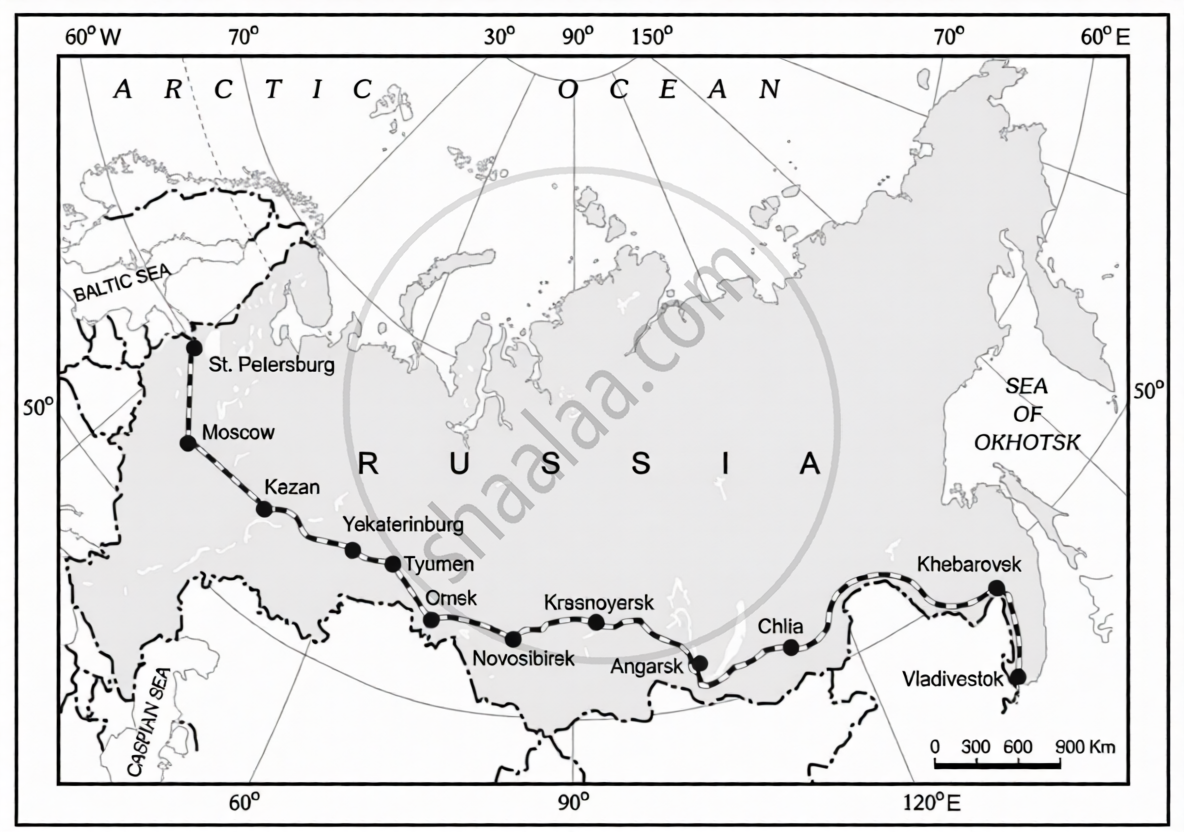
- Name the easternmost terminal station of the given rail route. (1)
- Name the most important agro centre along the rail route. (1)
- Name the Sea near to the westernmost terminal station. (1)
Chapter:
Read the given passage carefully and answer the questions that follow:
|
The Quaternary Sector The Quaternary Sector along with the Tertiary Sector has replaced most of the primary and secondary employment as the basis for economic growth. Over half of all workers in developed economies are in the ‘Knowledge Sector’ and there has been a very high growth in demand for consumption of information-based services from mutual fund managers to tax consultants, software developers and statisticians. Personnel working in office buildings, elementary schools and university classrooms, hospitals and doctors’ offices, theatres, accounting and brokerage firms all belong to this category of services. Like some of the tertiary functions, quaternary activities can also be outsourced. They are not tied to resources, affected by the environment, or necessarily localised by market. |
- Define the concept of ‘outsourcing’. (1)
- More than 50 percent of all workers in developed countries belongs to which sector of economy? (1)
- ‘Mutual funds managers’ are demanding which type of services? (1)
Chapter:
“The difficulties of the barter system were overcome by the introduction of money.” Support the statement with suitable arguments.
Chapter:
“Free trade can adversely affect the economies of developing countries.” Support the statement with suitable arguments.
Chapter:
Explain the importance of the ‘Northern Atlantic Sea Route’.
Chapter:
Study the given table carefully and answer the questions that follow:
| India - Trends of Urbanisation 1961 - 2011 |
||||
| Year | Number of Towns/UAs |
Urban Population (in Thousands) |
% of Total population |
Decennial Growth (%) |
| 1961 | 2,365 | 78,936.6 | 17.97 | - |
| 1971 | 2,590 | 1,09,114 | 19.91 | 38.23 |
| 1981 | 3,378 | 1,59,463 | 23.34 | 46.14 |
| 1991 | 4,689 | 2,17,611 | 25.71 | 36.47 |
| 2001 | 5,161 | 2,85,355 | 27.78 | 31.13 |
| 2011 | 6,171 | 3,77,000 | 31.16 | 31.08 |
- During which decade, the net increase in number of towns/UAs is the lowest?
- Mention the net increase in number of towns/UAs during 1981-91.
- Explain the decennial growth rate of urban population.
Chapter:
Explain the role of ‘border roads’ in the defence of the nation.
Chapter:
How do climate and mineral mining influence the distribution of world population? Explain with examples.
Chapter:
How do soil fertility influence the distribution of the world population? Explain with examples.
Chapter:
Advertisements
How do socio-cultural factors influence the distribution of the world population? Explain with examples.
Chapter:
Suggest any three measures to overcome the air pollution.
Chapter:
Suggest any three measures to overcome noise pollution.
Chapter:
“The earliest human beings depended on their immediate environment for their sustenance.” Examine the statement with reference to hunting and gathering.
Chapter:
“Commercial livestock rearing is well organised and capital intensive.” Examine the statement with comparison to nomadic herding.
Chapter:
“The distribution of rural Population in uneven across India.” Evaluate the statement.
Chapter:
Explain the problem of ‘low productivity’ of Indian agriculture.
Chapter:
Analyse the role of the ‘National Mission for Sustainable Agriculture’ to solve the low productivity problem.
Chapter:
Explain the problems of the ‘indebtedness’ of Indian farmers.
Chapter:
Analyse the importance of the ‘farmer’s portal’ in helping the farmers.
Chapter:
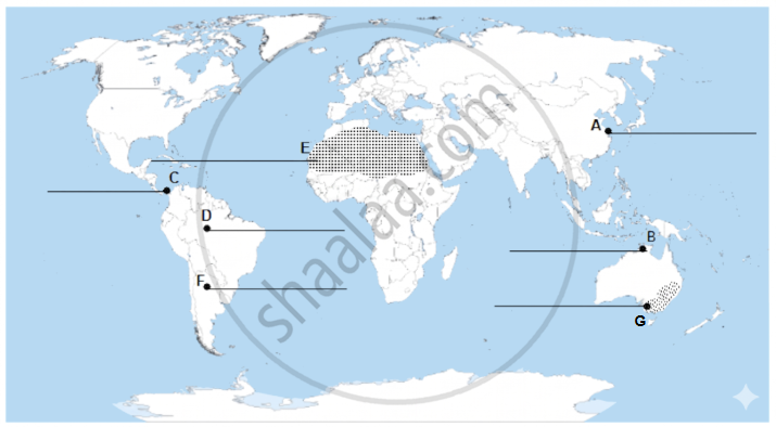
On the given political outline map of the world, seven geographical features have been marked as A, B, C, D, E, F and G. Identify any five with the help of the following information and write their correct names on the lines drawn near them:
- A major sea-port
- A major air-port
- A major shipping canal
- A major area of ‘subsistence gathering’
- A major area of ‘nomadic herding’
- A major area of ‘commercial livestock rearing’
- A major area of ‘extensive commercial grain farming’
Chapter:
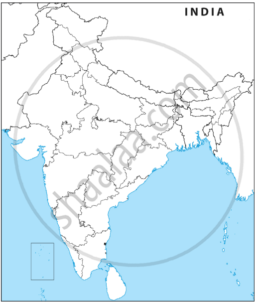
On the given political outline map of India, locate and label any five of the following seven geographical features with appropriate symbols:
- The state leading in the production of sugarcane.
- An oil refinery located in Bihar
- Important coal mines located in West Bengal
- Important iron-ore mines located in Coastal Maharashtra
- Important manganese mines located in Madhya Pradesh
- A major sea-port located in Odisha
- An important international airport in Telangana
Chapter:
Other Solutions
Submit Question Paper
Help us maintain new question papers on Shaalaa.com, so we can continue to help studentsonly jpg, png and pdf files
CBSE previous year question papers Class 12 Geography with solutions 2025 - 2026
Previous year Question paper for CBSE Class 12 Geography-2026 is solved by experts. Solved question papers gives you the chance to check yourself after your mock test.
By referring the question paper Solutions for Geography, you can scale your preparation level and work on your weak areas. It will also help the candidates in developing the time-management skills. Practice makes perfect, and there is no better way to practice than to attempt previous year question paper solutions of CBSE Class 12.
How CBSE Class 12 Question Paper solutions Help Students ?
• Question paper solutions for Geography will helps students to prepare for exam.
• Question paper with answer will boost students confidence in exam time and also give you an idea About the important questions and topics to be prepared for the board exam.
• For finding solution of question papers no need to refer so multiple sources like textbook or guides.
