Commerce (English Medium)
Science (English Medium)
Arts (English Medium)
Academic Year: 2024-2025
Date & Time: 24th February 2025, 10:30 am
Duration: 3h
Advertisements
General Instructions:
Read the following instructions carefully and follow them:
- This question paper contains 30 questions. All questions are compulsory.
- Question paper is divided into five Sections - Section A, B, C, D and E.
- Section A - Question Nos. 1 to 17 are Multiple Choice (MCQ) type questions. Each question carries 1 mark.
- Section B - Question Nos. 18 and 19 are Source based questions. Each question carries 3 marks.
- Section C - Question Nos. 20 to 23 are Short Answer (SA) type questions. Each question carries 3 marks. Answer to these questions shall be written in 80 to 100 words.
- Section D - Question Nos. 24 to 28 are Long Answer (LA) type questions. Each question carries 5 marks. Answer to these questions shall be written in 120 to 150 words.
- Section E - Question Nos. 29 & 30 are Map based questions. Each question carries 5 marks.
- In addition to this, NOTE that a separate question has been provided for Visually Impaired Candidates in lieu of questions having visual inputs, map etc. Such questions are to be attempted by Visually Impaired Candidates only.
- There is no overall choice given in the question paper. However, an internal choice has been provided in a few questions in all sections other than Section A.
“Human geography is the synthetic study of relationship between human societies and earth’s surface.” This definition of human geography is given by ______.
Vidal-de-la-Blache
Richard Hartshorne
Ritter
Ratzel
Chapter:
Which one of the following is the core concern of geography as a discipline?
To understand population distribution and the factors affecting the same.
To understand the relationship between resource distribution and its utilization.
To understand the earth as the home of human beings and its sustainability.
To understand the earth as the home of natural resources and their estimation.
Chapter:
The concept of ‘Neodeterminism’ was introduced by ______.
Ehrlich
C. Semple
Griffith Taylor
Humboldt
Chapter:
Read the following statements regarding outports carefully and choose the correct option:
- These are deep water ports.
- They are built away from the actual ports.
- These ports are also known as ferry ports.
- Piraeus is an example of outport for Athens in Greece.
Only (i), (ii) and (iii) are correct.
Only (i), (ii) and (iv) are correct.
Only (i), (iii) and (iv) are correct.
Only (ii), (iii) and (iv) are correct.
Chapter:
Assertion (A): ‘The chief gateways of the world are harbours and ports’.
Reason (R): ‘Cargoes and travellers are transported through them’.
(A) is correct, but (R) is incorrect.
(A) is incorrect but (R) is correct.
Both (A) and (R) are correct and (R) is the correct explanation of (A).
Both (A) and (R) are correct, but (R) is not the correct explanation of (A).
Chapter:
______ were originally developed for refuelling, watering and collecting food items.
Entreports
Ports of Call
Packet Stations
Comprehensive Ports
Chapter:
Arrange the following towns of India as per their location from north to south direction and choose the correct option:
- Nagpur
- Hyderabad
- Madurai
- Lucknow
(i), (iv), (ii), (iii)
(i), (iv), (iii), (ii)
(iv), (i), (iii), (ii)
(iv), (i), (ii), (iii)
Chapter:
Read the following statements regarding medieval towns in India carefully and choose the correct option:
- About 100 of the existing towns have their roots in medieval period.
- Varanasi, Madurai and Prayag are some of its examples.
- Most of the towns were developed as headquarters of the kingdoms.
- These are mostly fort towns built on ruins of ancient towns.
Only (i), (ii) and (iii) are correct.
Only (i), (ii) and (iv) are correct.
Only (i), (iii) and (iv) are correct.
Only (ii), (iii) and (iv) are correct.
Chapter:
Read the following statements related to international trade of India carefully and choose the correct option:
- India has a long coastline surrounded by ocean from three sides.
- Indian coasts have large number of well-developed sea ports.
- Kandla port exports huge amount of iron-ore.
- The transportation cost by water is very cheap for voluminous items.
Only (i), (ii) and (iv) are correct.
Only (i), (ii) and (iii) are correct.
Only (i), (iii) and (iv) are correct.
Only (ii), (iii) and (iv) are correct.
Chapter:
Assertion (A): ‘The agriculturally rich states of Punjab, Haryana and western Uttar Pradesh are facing the crisis of groundwater depletion.’
Reason (R): ‘More groundwater is utilised for irrigation than water- table recharge.’
Both (A) and (R) are correct and (R) is correct reason of (A).
Both (A) and (R) are correct, but (R) is not the correct reason of (A).
(A) is not correct, but (R) is correct.
(A) is correct, but (R) is not correct.
Chapter:
Read the following statements related to Indira Gandhi Canal Project carefully and choose the correct option:
- Indira Gandhi Canal project was conceived by Kanwar Sain in 1950 and it was launched in 1961.
- Introduction of canal irrigation has brought perceptible changes in the agricultural economy of the command area.
- Spread of canal irrigation has led to increase in cultivated area and crop intensity.
- Traditional crops of jowar, bajra has been replaced by rice and wheat ete.
(i), (ii) and (iv) only are correct.
(i), (ii) and (iii) only are correct.
(i), (iii) and (iv) only are correct.
(ii), (iii) and (iv) only are correct.
Chapter:
The watershed management programme in Jhabua district of Madhya Pradesh is funded by which one of the following ministries?
Rural Development
Environment
Transport
Irrigation
Chapter:
Advertisements
Local names like Panna, Para, Pali, Nagla, Dhani etc. are examples of which of the following types of rural settlements in India?
Clustered settlement
Semi-clustered settlement
Hamleted settlement
Dispersed settlement
Chapter:
Why is it that slums are the areas of residence with least choice? Choose the correct options:
- They have dilapidated houses with poor ventilation.
- The basic facilities like lights and toilets are difficult to get.
- Hygienic conditions and drinking water are improper.
- Better drainage facilities are available.
Only (i), (ii) and (iii) are correct.
Only (ii), (iii) and (iv) are correct.
Only (i), (iii) and (iv) are correct.
Only (i), (ii) and (iv) are correct.
Chapter:
| Composition of India’s export: 2009-2017 | ||||
| Commodities | 2009-10 | 2010-11 | 2015-16 | 2016-17 |
| Agriculture and allied products | 10.0 | 9.9 | 12.6 | 12.3 |
| Ore and minerals | 4.9 | 4.0 | 1.6 | 1.9 |
| Manufactured goods | 67.4 | 68.0 | 72.9 | 73.6 |
| Crude and petroleum products | 16.2 | 16.8 | 11.9 | 11.7 |
| Other commodities | 1.5 | 1.2 | 1.1 | 0.5 |
Under which one of the following categories of commodities, the increase in export is observed from 2010-11 to 2016-17?
Agriculture and allied products
Ore and minerals
Crude and petroleum products
Other commodities
Chapter:
| Composition of India’s export: 2009-2017 | ||||
| Commodities | 2009-10 | 2010-11 | 2015-16 | 2016-17 |
| Agriculture and allied products | 10.0 | 9.9 | 12.6 | 12.3 |
| Ore and minerals | 4.9 | 4.0 | 1.6 | 1.9 |
| Manufactured goods | 67.4 | 68.0 | 72.9 | 73.6 |
| Crude and petroleum products | 16.2 | 16.8 | 11.9 | 11.7 |
| Other commodities | 1.5 | 1.2 | 1.1 | 0.5 |
Under which one of the following category of commodities, increase in export is continuously observed?
Agriculture and allied products
Ore and minerals
Manufactured goods
Other commodities
Chapter:
| Composition of India’s export: 2009-2017 | ||||
| Commodities | 2009-10 | 2010-11 | 2015-16 | 2016-17 |
| Agriculture and allied products | 10.0 | 9.9 | 12.6 | 12.3 |
| Ore and minerals | 4.9 | 4.0 | 1.6 | 1.9 |
| Manufactured goods | 67.4 | 68.0 | 72.9 | 73.6 |
| Crude and petroleum products | 16.2 | 16.8 | 11.9 | 11.7 |
| Other commodities | 1.5 | 1.2 | 1.1 | 0.5 |
Under which one of the following category of commodities, maximum decline in export is recorded from 2015-16 to 2016-17?
Agriculture and allied products
Ore and minerals
Crude and petroleum products
Other commodities
Chapter:
| Composition of Total Cultivable Land | ||||
| Agricultural Land use Categories | As a percentage of Reporting Area | As a percentage of total Cultivable Land | ||
| 1950-51 | 2014-15 | 1950-51 | 2014-15 | |
| Culturable waste land | 8.0 | 4.0 | 13.4 | 6.8 |
| Fallow other than current fallow | 6.1 | 3.6 | 10.2 | 6.2 |
| Current fallow | 3.7 | 4.9 | 6.2 | 8.4 |
| Net area sown | 41.7 | 45.5 | 70.0 | 78.4 |
| Total Cultivable Land | 59.5 | 58.0 | 100.00 | 100.00 |
- Mention the reason for the decrease in cultivable waste land in 2014-15 as compared to 1950-51.
- Mention the reason for the increase in current fallow during 2014-15 as compared to 1950-51.
- Explain the reason of continuous increase in net area sown.
Chapter:
Read the passage carefully and answer the questions that follow:
|
Hunting and Food Gathering The earliest human beings depended on their immediate environment for their sustenance. They subsisted on: (a) animals which they hunted; and (b) the edible plants which they gathered from forests in the vicinity. Primitive societies depended on wild animals. People located in very cold and extremely hot climates survived on hunting. The people in the coastal areas still catch fish through fishing has experienced modernisation due to technological development. Many species, now have become extinct or endangered due to illegal hunting (poaching). The early hunters used primitive tools made of stones, twigs or arrows so the number of animals killed was limited. Gathering and hunting are the oldest economic activity known. These are carried out at different levels with different orientations. Gathering is practised in regions with harsh climatic conditions. It often involves primitive societies, who extract, both plants and animals to satisfy their needs for food, shelter and clothing. This type of activity requires a small amount of capital investment and operates at very low level of technology. The yield per person is very low and little or no surplus is produced. |
- Examine the impact of poaching on wild animals.
- Why was hunting of animals limited in early times? Explain.
- Why did early man depend upon his immediate natural environment? Explain.
Chapter:
Examine the role of climate, water availability and soil fertility on the distribution of world population.
Chapter:
Examine three stages of demographic transition theory.
Chapter:
Study the map of Rhine waterways and answer the questions that follow:
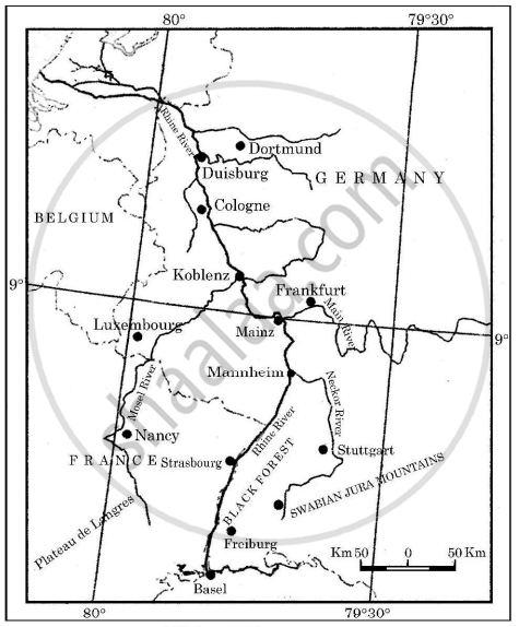
- Name the country in which most of Rhine river lies.
- Name two countries whose industrial areas are connected by river Rhine.
- Why is river Rhine world’s most heavily used waterway?
Chapter:
Explain the main features of State Highways in India.
Chapter:
Suggest the measures to solve the problems of slums in India.
Chapter:
Advertisements
Explain the main features of large scale manufacturing industries in the world.
Chapter:
Explain the main features of ‘High Tech’ industries in the world.
Chapter:
Assess the growth and significance of service sector in the development of the world economy.
Chapter:
Assess the growth and significance of transport and communication services in the world economy.
Chapter:
Analyse the growth of population in India since 1921.
Chapter:
With respect to adolescent population, analyse the challenges of Indian society.
Chapter:
In the Indian context, the non-conventional sources of energy are more equitably distributed and are environment friendly. In the context of this statement, analyse the future prospect of India in meeting its clean energy demand.
Chapter:
“Nuclear energy has emerged as a viable source in recent times.” Analyse the statement in context of India.
Chapter:
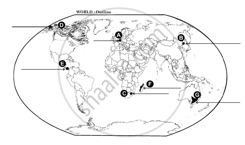
On the outline political map of the world, seven geographical features have been marked as A, B, C, D, E, F and G. Identify any FIVE of them and write their names on the lines drawn near them:
- Major sea port in Germany.
- Terminal station of Trans-Siberian Railway.
- An international airport.
- An area of subsistence gathering.
- An important waterway.
- An area of ‘Nomadic Herding’.
- An area of extensive commercial grain farming.
Chapter:
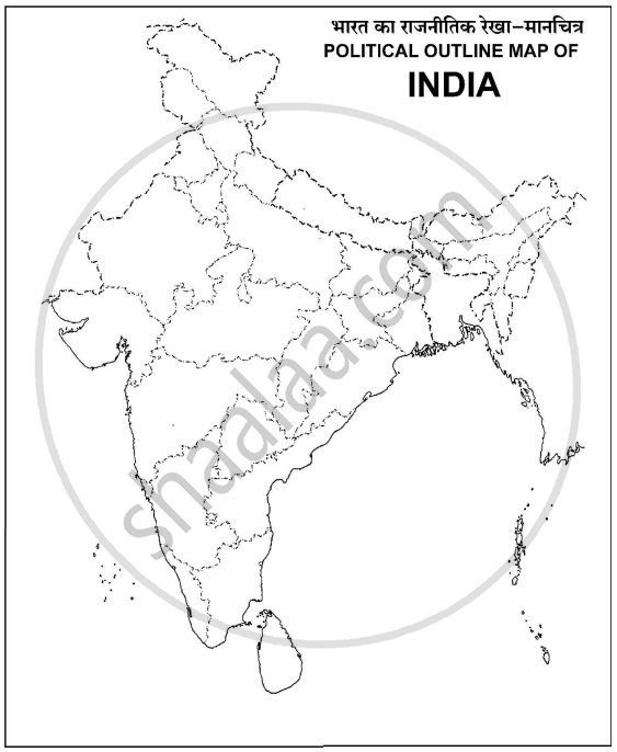
On the given political outline map of India, locate and label any five of the following geographical features with appropriate symbols.
- Important iron ore mines in Odisha.
- An important seaport in Kerala.
- A copper mine in Rajasthan.
- An oil refinery in Bihar.
- An international airport in Punjab.
- A state with highest density of population.
- A state leading in the production of jute.
Chapter:
Other Solutions
Submit Question Paper
Help us maintain new question papers on Shaalaa.com, so we can continue to help studentsonly jpg, png and pdf files
CBSE previous year question papers Class 12 Geography with solutions 2024 - 2025
Previous year Question paper for CBSE Class 12 Geography-2025 is solved by experts. Solved question papers gives you the chance to check yourself after your mock test.
By referring the question paper Solutions for Geography, you can scale your preparation level and work on your weak areas. It will also help the candidates in developing the time-management skills. Practice makes perfect, and there is no better way to practice than to attempt previous year question paper solutions of CBSE Class 12.
How CBSE Class 12 Question Paper solutions Help Students ?
• Question paper solutions for Geography will helps students to prepare for exam.
• Question paper with answer will boost students confidence in exam time and also give you an idea About the important questions and topics to be prepared for the board exam.
• For finding solution of question papers no need to refer so multiple sources like textbook or guides.
