Advertisements
Advertisements
प्रश्न
Which of the following shapes shows the coastal part of Brazil correctly?
विकल्प


Advertisements
उत्तर

Explanation:
Brazil’s coastline runs along the eastern side of the country, facing the Atlantic Ocean. On a map, the land mass of Brazil bulges eastward (and southeastward) into the ocean, so the coastal edge is a convex curve toward the right (east) side of the country.
APPEARS IN
संबंधित प्रश्न
State whether the following statement is true or false and correct the
false statement:
Brazil was under Portuguese rule for one and half century.
Is this sentence right or wrong? Rewrite the wrong ones.
The longitudinal extent of Brazil is less than India.
Is this sentence right or wrong? Rewrite the wrong ones.
Equator passes through the northern part of Brazil.
How are Brazil and India different from each other in terms of location?
Brazil is famous for ______ dance.
Write the answer in one sentence-
Which country is called ‘the coffee pot of the world’?
Write the answer in one sentence-
Location of Brazil is in which hemisphere?
Read the following map and answer the questions given below.
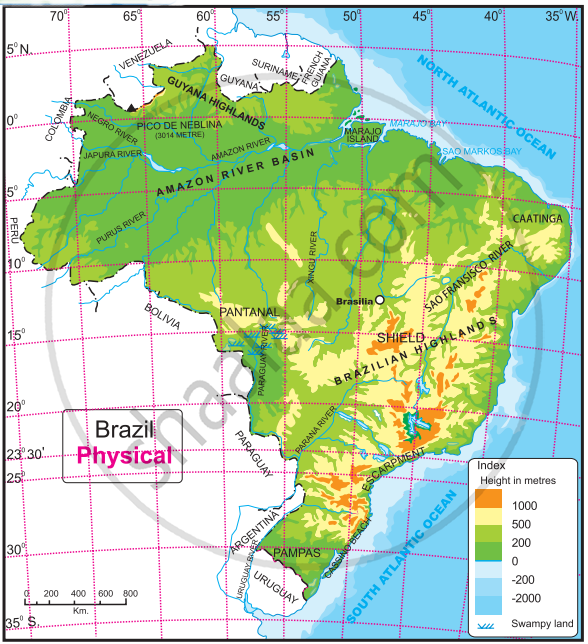
Questions-
- What is the range of the altitude of Amazon river basin?
- Between which two highlands is the Amazon river basin located?
- Write the height of the peak ‘Pico de Neblina’.
- Caatinga area is found at which direction of Brazil?
- Which grassland is located at south of Brazil?
Show the following in the outline map of Brazil with index.
- Condor
- The northernmost state of Brazil with less population density
- The southernmost state of Brazil which produces soyabean
- Victoria port
- Rio de Janerio-a tourist place
- Brasilia airport
Observe the map of Brazil and answer the following questions.

- Name the only port which may be considered inland.
- What are the modes of transport available from Brasilia?
- Name two tourist places with an airport and a port.
- What is the relative position of Cuiaba with respect to Brasilia?
- How can you reach Brasilia from Rio de Janeiro?
- Which is the tourist location in the extreme west?
