Advertisements
Advertisements
प्रश्न
See maps of Ichalkaranji city given below and observe how changes have occurred in the city over the years. Answer the questions that follow:
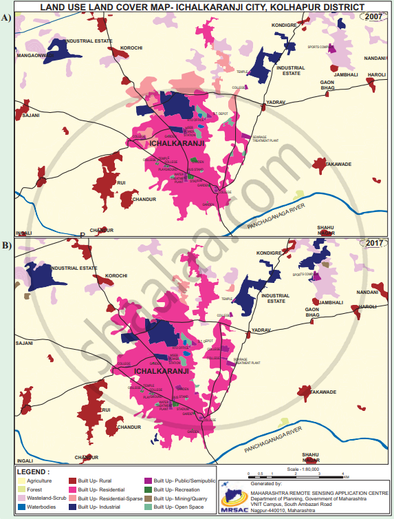
- Enlist the colours used for showing land uses in the index.
- What do the blue and the black lines show?
- What is the name of the river in the map?
- Name any two villages shown on the map.
- Which city is shown on the map?
- Which periods do the maps belong to?
- Which land covers have reduced? What are their colours?
- Which land covers seen to have increased? What are their colours?
- Which land covers have been replaced by the increased land covers?
- Write a conclusive note comparing both the maps.
विस्तार में उत्तर
Advertisements
उत्तर
- The index uses different colours such as yellow, light pink, dark red, bright pink, dark blue, green, brown and grey to represent different types of land use and land cover.
- The blue line shows the river, while the black lines show roads.
- The river shown is the Panchganga River.
- Any two examples are Korochi and Yadrav.
- The city shown is Ichalkaranji.
- The maps belong to the years 2007 and 2017.
- Agricultural land and some open/wasteland areas have reduced. Agricultural land is shown in yellow, while wasteland/open areas are shown in light shades such as pink or grey.
- Built-up residential and industrial areas have increased. Residential/built-up areas are shown mainly in pink/red shades, while industrial areas are shown in dark blue.
- The increased built-up and industrial areas have mainly replaced agricultural land, open land and wasteland.
- The 2017 map shows that Ichalkaranji expanded considerably compared with 2007. Residential, industrial and other built-up areas increased, while agricultural and open land decreased. This indicates rapid urbanisation, industrial growth and expansion of settlements in and around the city.
shaalaa.com
क्या इस प्रश्न या उत्तर में कोई त्रुटि है?
