Advertisements
Advertisements
प्रश्न
Saurabh and Ashwini work for a MNC. Two of their regional head offices are located in Brazil in Rio De Janeiro and Manaus, respectively. Both of them have to contact either of the head offices constantly. As they have to adjust timings according to their head offices, find out their corresponding timings in India, if they work according to office timings in Brazil, i.e., 10 am. to 5 pm.
Advertisements
उत्तर
1. Let’s assume Saurabh is coordinating with Rio De Janeiro’s head office, and Ashwini is coordinating with the head office of Manaus.
2. Brazil has four time zones. It is behind the GMT by 2, 3, 4 or 5 hours.
3. Rio De Janeiro is in the 2nd time zone, which is 3 hours behind GMT (GMT-03), and Manaus is in the 3rd time zone, which is 4 hours behind GMT (GMT-04).
4. Now, the time difference between GMT and IST is 5 hrs. 30 mins.
5. They have to make the following adjustments:
| Saurabh | ||
| Rio De Janeiro | GMT | IST |
| 10 a.m. | 1 p.m. | 6.30 p.m. |
| 5 p.m. | 8 p.m. | 1.30 a.m. |
| Ashwini | ||
| Manaus | GMT | IST |
| 10 a.m. | 2 p.m. | 7.30 p.m. |
| 5 p.m. | 9 p.m. | 2.30 a.m. |
Rio De Janeiro is in the 2nd time zone, which is 3 hours behind GMT (GMT-03), and Manaus is in the 3rd time zone, which is 4 hours behind GMT (GMT-04)
Corresponding timings in India Saurabh: 6.30 p.m. to 1.30 a.m. Ashwini: 7.30 p.m. to 2.30 a.m.
APPEARS IN
संबंधित प्रश्न
State whether right or wrong with reasons.
Brazil’s time is ahead of India’s time.
Write a note on importance of Standard Time.
It is 12 noon at Delhi. What would be the local time in Brasilia?
Differentiate between:
Communication in Brazil and India.
State whether right or wrong.
Brazilian standard time is ahead of Indian standard time.
Write a short note.
Development of communication in Brazil
Read the map in the figure and answer the following questions:
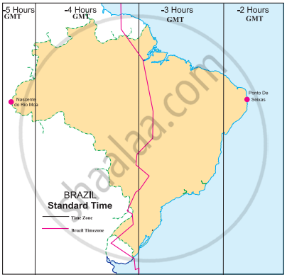
- How many divisions can you see in the map?
- What do these divisions signify?
- What does the term ‘behind the GMT’ mean?
- Which part of Brazil is ahead of the other?
- By how many minutes is this part ahead of others?
- What does the red line in the map show?
Given are the westernmost and easternmost extreme points of Brazil mainland in figure. Calculate the difference in time between the two points in minutes.
 |
Westernmost point: Nascente do Rio Moa (07°32'33'' S, 70°59' W)
Easternmost point: Ponta do Seixas, Paraíba (07°09' 28''S, 34°47' W)
Westernmost point: Nascente do Rio Moa (07°32'33'' S, 70°59' W) Easternmost point: Ponta do Seixas, Paraíba (07°09' 28''S, 34°47' W)
Observe the given map and answer the questions given below it.

- What does the above map indicate?
- How many time zones are shown in the map?
- Which part of Brazil is ahead of others?
- What does the dark line in the map show?
- To which direction does Ponto De Seixas lie?
