Advertisements
Advertisements
प्रश्न
Observe the map and answer the following questions:
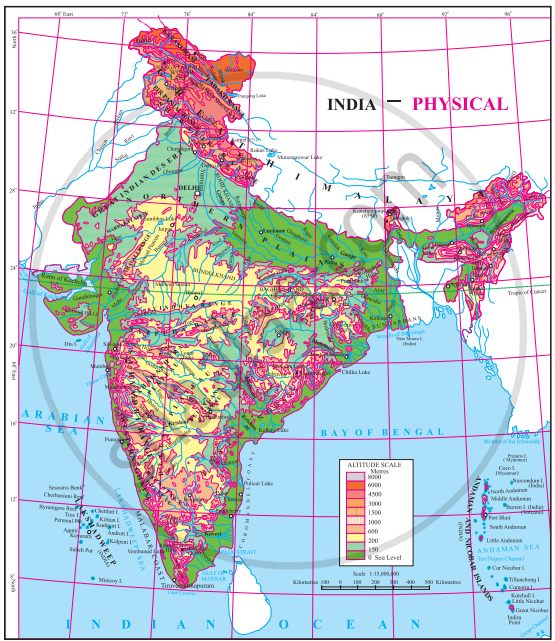
- In which direction does the region with an altitude of more than 6000 m lie in India?
- Look for the south-flowing river in the peninsular region. In which river basin does it lie?
- In which direction is the slope of the region in the north shown in dark green?
- Make a list of plateaus located in between the Aravali ranges and the Chhota Nagpur Plateau.
- Name the peak shown in the Eastern Ghats.
- Which mountains demarcate the deep plains of the Brahmaputra?
- Give the relative location of the Nilgiri Hills.
- In which direction does the height of the Sahyadri hills increase?
- The Vindhyas act as a water divide between which two river basins?
- In which direction do the Aravalis lie?
- Aravali ranges act as a water divide between which rivers?
- Name the hills located on the plateaus to the east of the Aravalis.
- Across which states have the Deccan Plateau spread?
- Which hill ranges lie to the west of the Deccan Plateau?
- Enumerate the characteristics of the Western Ghats.
- Compare the Eastern and the Western Ghats.
- Why are the Western Ghats called a water divide?
विस्तार में उत्तर
Advertisements
उत्तर
- The region with an altitude of more than 6000 m lies in the part of India towards the north and northeast.
- The Wardha and Vainganga are the south-flowing rivers in the peninsular region. These lie in the Godavari river basin.
- The region in the north shown in dark green is the North Indian Plain. It slopes towards the east.
- Plateaus located in between the Aravalli ranges and Chhota Nagpur Plateau are Mewad Plateau, Bundelkhand, Baghelkhand and Malwa Plateau.
- Mahendragiri (1690 m) and Malayagiri (1187 m) are the peaks shown in the Eastern Ghats.
- Dafla Hills, Naga Hills, Garo, Khasi and Jaintia Hills demarcate the deep plains of Brahmaputra.
- The Nilgiri Hills lie at the convergence of the Western Ghats and the Eastern Ghats in the southern part of the Deccan Pleateau.
- The height of the Sahyadri Hills increases towards the south.
- The Vindhyas act as a water divide between the Ganga river system and the Narmada river system.
- The Aravallis lie in the northwestern direction.
- The Aravali ranges act as a water divide between river Luni which originates along the western slopes of Aravali range and River Banas which originates along the eastern slopes of Aravali range.
- The Vindhya Range (or Vindhyan Hills) is the prominent hill range located on the plateau to the east of the Aravali Range, lying between the Aravali and the plateau. This region also includes the Malwa Plateau.
- The Deccan Plateau is spread across the states of Telangana, Maharashtra, Tamil Nadu, Karnataka, Kerala, Madhya Pradesh, Chhattisgarh, and Andhra Pradesh.
- The Western Ghats, also called the Sahyadri, are a north-south chain of mountains or hills that mark the western edge of the Deccan Plateau region.
- The characteristics of the Western Ghats are:
- They rise steeply from the west coast and originate from the Tapti River, till Kanyakumari.
- They are higher than the Eastern Ghats and have an average height of 900 to 1100 m, the highest peak being Anai Mudi.
- The hills are continuous with an average width of 50 to 80 metres.
- Many important rivers of the Deccan plateau originate from these ghats.
- They lie perpendicular to the southwest monsoon winds, causing heavy rainfall on their windward side.
-
Eastern Ghats Western Ghats The Eastern Ghats mark the eastern edge of the Deccan Plateau. The Western Ghats mark the western edge of the Deccan Plateau. Eastern Ghats are broad. Western Ghats are very narrow. Eastern Ghats receive less rainfall. Western Ghats receive more rainfall. Eastern Ghats are discontinuous and irregular. Western Ghats are continuous and regular; hence, they possess higher elevation The Eastern Ghats have Mahindra Giri as their highest peak. The Western Ghats have Anai Mudi and Dodda Beta as their highest peaks. - The Western Ghats are the highest boundary line of many peninsula and Konkan rivers. It divides basins of the east-flowing Peninsular river from those of Konkan and Malabar rivers, which are west-flowing rivers. Hence, the Western Ghats are major water divides of peninsular India.
shaalaa.com
क्या इस प्रश्न या उत्तर में कोई त्रुटि है?
