Advertisements
Advertisements
प्रश्न
Mark the following in the outline map of India. Write the names and give the index.

- Indira Point
- River Ganga
- Chhota Nagpur Plateau
- Mawsynram
- High Population Zone
- Andaman and Nicobar Islands
Advertisements
उत्तर

APPEARS IN
संबंधित प्रश्न
Read the following graph and answer the questions.
Temperature and Rainfall in Brazil and India
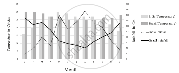
- What is the minimum and maximum temperature of India
- What difference do you find in the rainy period in Brazil and India?
- In which month does Brazil get less rainfall?
- In which month does India get higher rainfall?
- In which month does India get less rainfall?
- In which month does Brazil have a higher temperature?
The easternmost longitude of India is
Considering hemisphere, which shape correctly represents the hemisphere in which India lies?
Fill in the blank:
______ is referred to as the National Capital Territory of India.
On a Political Map of India, show all the States and Union territories of India along with their Capitals.
What is the percentage of land area that India occupies with respect to the world?
Name the Eastern Coastal States of India.
The ______ latitude passes through the middle of the country.
Why is India called a Sub-continent? How it is separated?
Collect information about the ‘Silk Route’. Also find out the new developments, which are improving communication routes in the regions of high altitude.
