Advertisements
Advertisements
प्रश्न
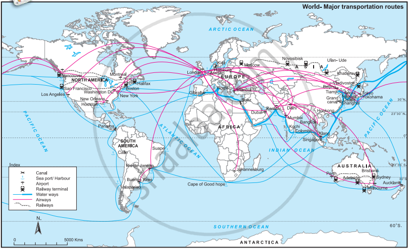 Look at the map in Fig. 6.2 and answer the following questions:
- Which means of transportation are shown in the map?
- Between which continents do you see an overall higher flow of transportation?
- Which canals can you see in the waterways? What could be their purpose?
- Which two major cities in India are connected internationally through airways?
- Which two continents show a lesser use of air routes?
- Which two continents show a lesser use of rail routes ? Why?
- Which rail route connects two continents?
- Why do you see a concentration of transportation routes in the southern part of Australia as opposed to northern parts in all the continents?
- Which continent does not have contineous internal rail routes? Why?
विस्तार में उत्तर
Advertisements
उत्तर
- The map shows airways, waterways and railways.
- A higher flow of transportation is seen between North America and Europe, and between Europe and Asia.
- The important canals shown are the Suez Canal and Panama Canal. They shorten sea routes and save time, distance and transport cost.
- Mumbai and Delhi are major Indian cities connected internationally through airways.
- Africa and South America show comparatively lesser use of air routes.
- Africa and Australia show comparatively fewer rail routes. This is because of low population density, large desert areas, difficult terrain and fewer industrial centres in many regions.
- The Trans-Siberian Railway and its connecting routes towards Europe and Asia form an important intercontinental rail connection across the Eurasian landmass.
- Southern Australia has a higher population concentration, more cities, industries, agriculture and economic activities. Therefore, transport routes are more developed there than in the sparsely populated northern and interior regions.
shaalaa.com
क्या इस प्रश्न या उत्तर में कोई त्रुटि है?
