Advertisements
Advertisements
प्रश्न
Give a geographical reason for the following:
Jaipur has a higher annual range of temperature than Mumbai.
Advertisements
उत्तर
Jaipur has a higher annual range of temperature because it is located in the interior of the continent and hence experiences the continental type of climate. While summers are extremely hot, winters are extremely cold. On the other hand, Mumbai is located near the coast and experiences the equable type of climate.
APPEARS IN
संबंधित प्रश्न
Study the climatic data given below and answer the questions that follow:
| Month | Jan | Feb | Mar | Apr | May | June | July | Aug | Sep | Oct | Nov | Dec |
| Temperature in °C |
12.0 | 25.5 | 26.3 | 27.1 | 30.0 | 36.2 | 36.0 | 35.9 | 30.3 | 28.4 | 21.0 | 16.6 |
| Rainfall cm | 1.5 | 0.1 | 0.0 | 1.4 | 1.1 | 21.0 | 25.3 | 27.2 | 24.0 | 9.4 | 1.5 | 0.4 |
1) What is the annual range of temperature of the station?
2) What is the total annual rainfall experienced by the station?
3) Why would it be correct to presume that the station lies in the interior and not on the coast?
Give a geographical reason for each of the following:
The Konkan coast experience orographic rainfall.
Mention the geographical reason for the following:
Western Rajasthan receives no rain from the Arabian Sea branch of the South West Monsoon winds.
Study the data of distribution of temperature and rain for Station X and answer the questions that follow :

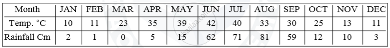
(i) Is Station X in the coastal area or in the interior of the country?
(ii) Calculate the total annual rainfall for Station X.
(iii) Name the wind that brings most of the rainfall to Station X.
- Name two rainiest stations.
- Name two driest stations.
- Two stations with the most equable climate.
- Two stations with the most extreme climate.
- Two stations are most influenced by the Arabian branch of southwest monsoons.
- Two stations are most influenced by the Bay of Bengal branch of south-west monsoons.
- Two stations influenced by both branches of the south-west monsoons
- Two stations influenced by retreating and north-east monsoons.
- Two stations are receiving winter showers from the western disturbances.
- The two hottest stations in the months of
- February
- April
- May
- June
Which parallel of latitude divides India into the northern and southern halves.
How are the sources of rainfall in the North-west part of India different from the rainfall experienced on the coastal areas of Eastern India in winter?
Why does the Tamil Nadu coast get rainfall in October?
Given below is the climatic data of a station. Study the table and answer the questions that follow:
| Month | Jan. | Feb. | Mar. | Apr. | May | June | July | Aug. | Sep. | Oct. | Nov. | Dec. |
| Temperature °C | 24.5 | 25.7 | 27.7 | 20-4 | 30.0 | 32.5 | 31.0 | 30.2 | 29.8 | 28.0 | 25.9 | 24.7 |
| Rainfall cm | 4.6 | 1.3 | 1.3 | 1.8 | 3.8 | 4.5 | 8.7 | 11.3 | 11.9 | 30.6 | 35.0 | 13.9 |
- Calculate the annual rainfall experienced by the station.
- What is the annual range of temperature?
- Name the wettest month.
The highest rainfall region in India is located in this state.
