Advertisements
Advertisements
प्रश्न
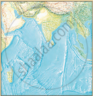
- From the map of the ocean floor identify the ocean.
- Can you identify and name the submerged landforms shown in the diagram?
- Which region would be ideal for fishing and why?
दीर्घउत्तर
Advertisements
उत्तर
- Indian Ocean.
- Yes. The submerged landforms shown in the diagram are:
- Continental Shelf
- Continental Slope
- Abyssal Plain
- Submerged/Mid-Oceanic Mountain Range (Ridge)
- Marine Trench/Deep
- The Continental Shelf is ideal for fishing because it is the shallowest part of the ocean bed, so sunlight reaches its bed and algae and plankton grow there. These form food for fish, and therefore extensive fishing grounds are found on the continental shelf.
shaalaa.com
क्या इस प्रश्न या उत्तर में कोई त्रुटि है?
