Advertisements
Advertisements
प्रश्न
Compare either Map 1 or Map 2 with the present-day map of the subcontinent, listing as many similarities and differences as you can find.
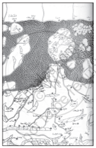
Map 1
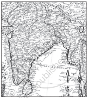
Map 2
Advertisements
उत्तर
Map 1 and Map 2 given in the NCERT Textbook represent two different times. Map 1 was made in 1154 CE by al-Idrisi, an Arab geographer. This section is a detail of the Indian subcontinent from his larger map of the world. Map 2 was made by a French cartographer in 1720. Both maps are quite different from each other, even though they represent the same area. In Map 1 we find south India at the place where we would expect to find north India and Sri Lanka is the island at the top. The place names are in Arabic. Some familiar places like Kanauj in Uttar Pradesh have been spelt as Qanauj. In comparison to this Map 2 was made nearly 600 later after Map 1. By that time information about the subcontinent had changed a lot. This map appears to be more familiar to us. The coastal areas, particularly, are more detailed.
APPEARS IN
संबंधित प्रश्न
Very Short Answer Type Question:
Who was al-Idrisi?
Very Short Answer Type Question:
Who used the term Hindustan for the first time and when?
Very Short Answer Type Question:
What do you mean by archives?
Very Short Answer Type Question:
Who were scribes?
Very Short Answer Type Question:
What changes took place during 700 and 1750?
Very Short Answer Type Question:
Who were the patrons?
Very Short Answer Type Question:
How history was divided by historians during the middle of the nineteenth century?
Very Short Answer Type Question:
What was the basis of such division?
Short Answer Type Question:
What do you mean by pan-regional rule? What was its impact?
Long Answer Type Question:
What was the change in the religion of the time? Trace out major developments?
