Please select a subject first
Advertisements
Advertisements
Observe the given figure and write the answers.
 |
- Which region gets more than 4000 mm of rainfall?
- Identify the regions with maximum and minimum temperatures?
- In which direction is the temperature increasing?
- Identify the direction of the winds shown. What are they known as?
- Which winds are responsible for the rainfall in India ?
- Some part of Rajasthan is under desert? What could be the reason for it?
- Draw the main parallel of latitude passing through India which affects its climate.
- In which part of Peninsular India are semi-arid climatic conditions found and why?
Concept: undefined >> undefined
Look at fig. Observe the logos given below and answer the following questions.
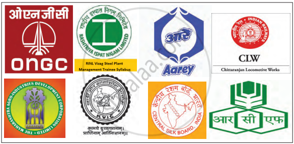
- Identify the industries with which they are associated.
- Which raw material is used for these industries. Classify them accordingly.
- From which part of India do they get these raw materials? Discuss and write.
Concept: undefined >> undefined
Advertisements
Read the map in the figure and answer the following questions:
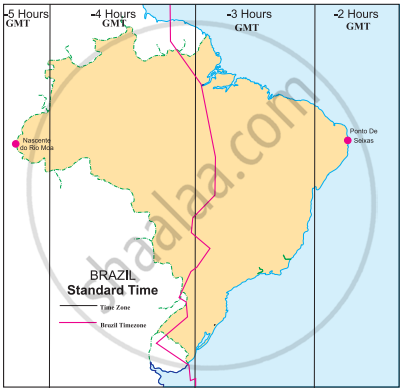
- How many divisions can you see in the map?
- What do these divisions signify?
- What does the term ‘behind the GMT’ mean?
- Which part of Brazil is ahead of the other?
- By how many minutes is this part ahead of others?
- What does the red line in the map show?
Concept: undefined >> undefined
Given are the westernmost and easternmost extreme points of Brazil mainland in figure. Calculate the difference in time between the two points in minutes.
 |
Westernmost point: Nascente do Rio Moa (07°32'33'' S, 70°59' W)
Easternmost point: Ponta do Seixas, Paraíba (07°09' 28''S, 34°47' W)
Westernmost point: Nascente do Rio Moa (07°32'33'' S, 70°59' W) Easternmost point: Ponta do Seixas, Paraíba (07°09' 28''S, 34°47' W)
Concept: undefined >> undefined
Saurabh and Ashwini work for a MNC. Two of their regional head offices are located in Brazil in Rio De Janeiro and Manaus, respectively. Both of them have to contact either of the head offices constantly. As they have to adjust timings according to their head offices, find out their corresponding timings in India, if they work according to office timings in Brazil, i.e., 10 am. to 5 pm.
Concept: undefined >> undefined
Observe the given map and answer the questions given below it.

- What does the above map indicate?
- How many time zones are shown in the map?
- Which part of Brazil is ahead of others?
- What does the dark line in the map show?
- To which direction does Ponto De Seixas lie?
Concept: undefined >> undefined
Choose the odd man out:
Region with very high rainfall in India.
Concept: undefined >> undefined
Brazil is the largest exporter of ______ in the world.
Concept: undefined >> undefined
The Lakshadweep Islands of Arabian Sea are ______.
Concept: undefined >> undefined
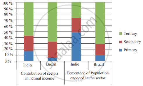
Study the following graph and analyse in short.
Concept: undefined >> undefined
Read the adjoining table and answer the following questions.
| Export, Import and Balance of Trade (Value in US $) | ||||
| India | Brazil | |||
| Year | Exports | Imports | Exports | Imports |
| 2009 - 10 | 178751.4 | 288372.9 | 152994.7 | 127647.3 |
| 2010 - 11 | 251136 | 369770 | 197356.4 | 180458.8 |
| 2011 - 12 | 304623.53 | 489181.3 | 256038.7 | 226243.4 |
| 2012 - 13 | 214099.8 | 361271.9 | 242579.8 | 223149.1 |
- What is balance of trade?
- Tell the types of balance of trades.
- In which country export exceeds import in all the years?
- Brazil’s balance of trade belong to which type?
- India’s balance of trade belong to which type?
Concept: undefined >> undefined
Which means of communication has expedited the field of communications?
Concept: undefined >> undefined
Match the columns.
| ‘A’ Group | ‘B’ Group |
| (a) Trans-Amazonian | (i) Tourist Place Highway |
| (b) Road Transport | (ii) Railway Station in India |
| (c) Rio de Janeiro | (iii) Golden Quadrilateral |
| (d) Manmad | (iv) Major Highways |
| (v) 40° W. Meridian |
Concept: undefined >> undefined
Write a note on modern means of communication.
Concept: undefined >> undefined
On what basis will you decide how many standard times should be there in a country?
Concept: undefined >> undefined
Match the following:
| A | B | ||
| 1. | Trans Amazonian route | a. | Tourist spot |
| 2. | Road transportation in India | b. | Railway station in India |
| 3. | Rio de Janerio | c. | Golden quadrilateral highway |
| d. | Important transport route of Brazil |
Concept: undefined >> undefined
What is communication?
Concept: undefined >> undefined
Write a short note.
Communication in India
Concept: undefined >> undefined
Prepare a simple bar graph with the help of given statistical information and answer the questions given below:
| Export of India to Brazil (million US dollars) |
|
| Year | Export |
| 2008 | 3700 |
| 2009 | 2200 |
| 2010 | 4200 |
| 2011 | 6100 |
| 2012 | 5000 |
Questions:
- How much export was found in 2008?
- In which year highest export of India was found?
- How much export increased in millions between 2009 and 2011?
Concept: undefined >> undefined
Which longitude in India is considered as Indian Standard Time?
Concept: undefined >> undefined
