Advertisements
Advertisements
Read the adjoining table and answer the following questions.
| Export, Import and Balance of Trade (Value in US $) | ||||
| India | Brazil | |||
| Year | Exports | Imports | Exports | Imports |
| 2009 - 10 | 178751.4 | 288372.9 | 152994.7 | 127647.3 |
| 2010 - 11 | 251136 | 369770 | 197356.4 | 180458.8 |
| 2011 - 12 | 304623.53 | 489181.3 | 256038.7 | 226243.4 |
| 2012 - 13 | 214099.8 | 361271.9 | 242579.8 | 223149.1 |
- What is balance of trade?
- Tell the types of balance of trades.
- In which country export exceeds import in all the years?
- Brazil’s balance of trade belong to which type?
- India’s balance of trade belong to which type?
Concept: undefined >> undefined
Which means of communication has expedited the field of communications?
Concept: undefined >> undefined
Advertisements
Match the columns.
| ‘A’ Group | ‘B’ Group |
| (a) Trans-Amazonian | (i) Tourist Place Highway |
| (b) Road Transport | (ii) Railway Station in India |
| (c) Rio de Janeiro | (iii) Golden Quadrilateral |
| (d) Manmad | (iv) Major Highways |
| (v) 40° W. Meridian |
Concept: undefined >> undefined
Write a note on modern means of communication.
Concept: undefined >> undefined
On what basis will you decide how many standard times should be there in a country?
Concept: undefined >> undefined
Match the following:
| A | B | ||
| 1. | Trans Amazonian route | a. | Tourist spot |
| 2. | Road transportation in India | b. | Railway station in India |
| 3. | Rio de Janerio | c. | Golden quadrilateral highway |
| d. | Important transport route of Brazil |
Concept: undefined >> undefined
What is communication?
Concept: undefined >> undefined
Write a short note.
Communication in India.
Concept: undefined >> undefined
Prepare a simple bar graph with the help of given statistical information and answer the questions given below:
Export of India to Brazil (million US dollars)
| Year | Export |
| 2008 | 3700 |
| 2009 | 2200 |
| 2010 | 4200 |
| 2011 | 6100 |
| 2012 | 5000 |
Questions:
- How much export was found in 2008?
- In which year highest export of India was found?
- How much export increased in millions between 2009 and 2011?
Concept: undefined >> undefined
Which longitude in India is considered as Indian Standard Time?
Concept: undefined >> undefined
Which is an important part of the economy and trade of any country?
Concept: undefined >> undefined
Study the map given in the figure and answer the following questions.
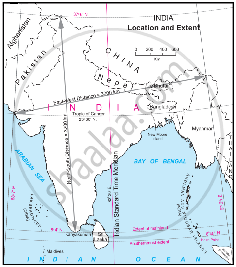
- Calculate the difference between the two longitudinal extremes of mainland India. Is it more than Brazil?
- Which longitude in India is called the Indian Standard Time (IST)?
- What is the difference between this time and the GMT?
- How many local times are there in India?
Concept: undefined >> undefined
Read the graph and answer the following questions:

- What type of graph is shown?
- what are the factors shown in the graph?
- In which year do you find the percentage of GDP similar?
- In the year 2010 in India, what is the percentage of GDP in trade?
- In the year 2000 which country's percentage of GDP in trade was the highest?
- In the year 2016, what is the difference in the percentage of GDP in trade of India and Brazil?
Concept: undefined >> undefined
Identify the correct option with the help of the given statement:
It is a rain shadow region in Brazil
a) Pantanal b) Pampas
c) Amazon river basin d) Northern part of the highlands
Concept: undefined >> undefined
Brazil is convered mainly by ____________.
Concept: undefined >> undefined
Brazil is covered mainly by ______.
Concept: undefined >> undefined
Maximum part of Brazil is occupied by ______.
Concept: undefined >> undefined
Like India, Brazil also has ______.
Concept: undefined >> undefined
Write answer in one sentence-
Which is the highest peak in Brazil?
Concept: undefined >> undefined
The southern part of Brazil is covered by ______.
Concept: undefined >> undefined
