Please select a subject first
Advertisements
Advertisements
What do you understand by topographic maps?
Concept: undefined >> undefined
Advertisements
Which map would be most useful to army personnel when constructing a bridge during a war?
Concept: undefined >> undefined
How will you show the location of your house to a friend who is visiting you for the first time?
Concept: undefined >> undefined
Differentiate between a plan and a sketch.
Concept: undefined >> undefined
What are the different types of maps?
Concept: undefined >> undefined
Briefly describe the importance of mountains.
Concept: undefined >> undefined
Picture study
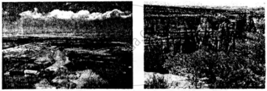
Look at the photographs of a plain and a plateau given here and answer the questions.
- How does a plain look different from a plateau?
- Why are river plains thickly populated?
- How is life in the plains different from life in the mountains?
Concept: undefined >> undefined
How does the shape of the continent affect the climate of the southern part of South America?
Concept: undefined >> undefined
Mention some of the factors that affect the climate of South America
Concept: undefined >> undefined
Name the summer and winter months in large parts of South America.
Concept: undefined >> undefined
Which winds bring heavy rainfall to the Guiana Highlands and Brazil?
Concept: undefined >> undefined
Why is the Atacama a desert?
Concept: undefined >> undefined
Is the Atacama a tropical desert or a temperate desert?
Concept: undefined >> undefined
Quito is located near the equator yet it has a cool pleasant climate throughout the year. Explain.
Concept: undefined >> undefined
Answer the following question in brief.
What is meant by the scale of a map?
Concept: undefined >> undefined
Answer the following question in brief.
Which three ways are used to represent the scale of a map?
Concept: undefined >> undefined
Look closely at the political map of India in your atlas and make a note of your observations and calculations in your notebook.
What is the scale of the map?
Concept: undefined >> undefined
Look closely at the political map of India in your atlas and make a note of your observations and calculations in your notebook.
Calculate the N-S and E-W extents of India.
Concept: undefined >> undefined
Complete the following chart
| Distance on | Distance | Scale |
| the map | on ground | |
| Example: 5 cm | 25 km | 1 cm = 5 km |
| 10 cm | 100 km | ___________ |
| 2 cm | ___________m | 1 cm = 30 km |
| ___________ | 49 m | 1 cm = 7 m |
| 6 cm | 60,000 km | __________ |
Concept: undefined >> undefined
