Advertisements
Advertisements
प्रश्न
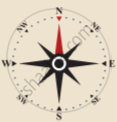
Write a note on directions with relevant diagram.
Advertisements
उत्तर
Direction:
Maps are drawn normally with north orientation. The North direction in a map is always towards the North Pole of the earth. If you position yourself looking at the North Pole, on your right will be the east; your left will be the west; at your back will be south. These four main directions are called the cardinal directions. The direction is usually indicated on a map by a North-South line, with the North direction represented by an arrowhead.
APPEARS IN
संबंधित प्रश्न
___________ indicates the purpose or theme of the map.
What is a map?
Mention a few surveying instruments.
Grid references are essential to find the exact location of places on a map.
What do you mean by the term 'scale of the map'?
International boundaries are marked in ______ colour codes.
What is meant by cybercartography?
What are the colour codes used with map symbols?
What do you mean by ‘Direction’?
State the essential features of a map.
