Advertisements
Advertisements
प्रश्न
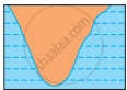
Which of the following shapes show the coastal part of India correctly?
पर्याय
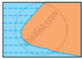
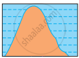
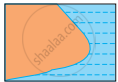
MCQ
Advertisements
उत्तर
shaalaa.com
या प्रश्नात किंवा उत्तरात काही त्रुटी आहे का?
APPEARS IN
संबंधित प्रश्न
Find the odd man out :
States in India :
Describe the latitudinal and longitudinal extent of India and Brazil.
Considering hemisphere, which shape correctly represents the hemisphere in which India lies?
What do you know about the Purvanchal ranges?
Answer the following question in one or two paragraphs:
Explain how India has benefited from its location.
The Southernmost point of India is ______.
India is situated into southern part of ______.
Why do we need a Standard Meridian for India?
Show the following in the outline map of India with index.
- Thar desert
- Ladakh
- 0-20% urbanization state at the east of India
- Apple producing state at north most of India
- Chennai port
- Kanyakumari-a tourist centre
India is located in the ______ hemispheres of the earth.
