Advertisements
Advertisements
प्रश्न
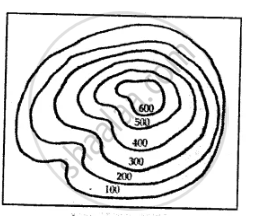
What is a contour line?
Advertisements
उत्तर
A contour line is an imaginary line on a map connecting points at the same height above sea level.
APPEARS IN
संबंधित प्रश्न
Contour lines on a map join points of equal ______ on the surface or the earth above or below a reference point.
How does relief of an area affect land use?
Why do you think that the knowledge of scale is important for reading a map?
Choose the correct answer:
This scale is stated in words
What is meant by the scale of a map?
Which three ways are used to represent the scale of a map?
Convert the statement scale 1 cm = 100 km into R.F. scale.
What method would you use to measure the length of a river?
Look at the picture and answer the question

What type of scale is shown alongside?
Look at the picture and answer the question

State a feature of this scale.
