Advertisements
Advertisements
प्रश्न
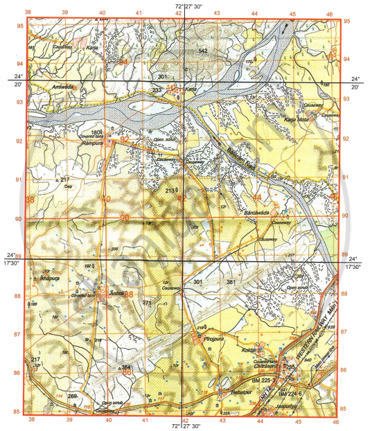
Study the extract of the Survey of India Map Sheet No. G43S7 and answer the following questions:
-
- What is the social significance of the temple that is found at the six-figure grid reference 362001?
- What is the reason for very few settlements in the southeastern quarter of the map extract?
-
- What is .3r in grid square 3501?
- Identify one relief feature found in the grid square 3796.
-
- The area shown on the map extract has seasonal streams, but in 3903, a large perennial water source can be seen. What may be the reason for the presence of this large perennial source of water?
- Which other source of water seen on the map extract is perennial?
-
- While travelling for work from Dhaneri (3100) to Marwada (3197) along the metalled road, Sahil crossed over a number of ‘causeways’. Why are causeways present in the area shown on the map extract?
- Identify the drainage pattern seen in the grid square 3697.
-
- What is the difference in altitude between the highest point on the map extract and the contour height in grid square 3203?
- What is the black horizontal line made between 98 and 99 northings called?
सविस्तर उत्तर
Advertisements
उत्तर
-
- It serves as a place of worship for the local community and is frequently used as a location for social meetings, festivals, or fairs, encouraging communal harmony.
- The southeastern section is characterised by high relief, steep slopes, and extensive vegetation (as represented by green wash), rendering the terrain unsuited for agriculture and construction.
-
- It represents a relative height of 3 meters for a sand dune or a dry tank embankment.
- A ridge or a steep slope is indicated by closely packed contours.
-
- The presence of a perennial lined well or a perennial tank fed by underground water sources or springs, as opposed to seasonal streams that depend on rainfall.
- Perennial-lined wells (blue circles) or a perennial river (blue water tint).
-
- Causeways are constructed over seasonal streams (dry nullahs) that overflow during the monsoon. They let cars cross the stream bed when the water level is low.
- Dendritic drainage pattern
-
- Difference in altitude:
Highest point on map = 542 m
Contour height in 3203: 280 m
Difference: 542 − 280
= 262 m - It is the Latitude line (specifically the 24° 30' N line if it is the central dividing line of the sheet).
- Difference in altitude:
shaalaa.com
या प्रश्नात किंवा उत्तरात काही त्रुटी आहे का?
