Some streams shown in the given map extract do not merge with the main river because they flow through sandy soil, which absorbs their water before they can reach it. The streams near Ramsida are examples of such streams.
Advertisements
Advertisements
प्रश्न
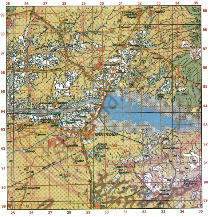
Study the extract of the Survey of India Map Sheet No. G43S7 and answer the following questions [Eastings 25-35, Northings 89-99]:
-
- Give the four-figure grid reference of the settlement of Nilpur.
- Give the six-figure grid reference of Chhatri north of Vadavas.
-
- State the compass direction of the settlement of Ratanpur from the settlement of Marwada.
- State two advantages that Dantiwada, south of river Banas has over other settlements in the region in the given map extract.
-
- What are the brown dotted clusters in the southern part of the given map extract? Also state what the letters Dep in the same area indicate.
- Explain why some of the streams in the south-eastern part of the given map extract do not join the main river? Name the settlement where these streams can be seen.
-
- What is the general pattern of human habitation (settlement) in the given map extract?
- Measure the length of the aqueduct in metres from the point whose six-figure grid reference is 261920 to the point whose six-figure grid reference is 274929.
-
- Name the two types of dams shown in the given map extract.
- How does the drainage pattern in grid square 2698 differ from the pattern of streams in grid square 2697?
स्पष्ट करा
सविस्तर उत्तर
Advertisements
उत्तर
-
- 2891
- 333964
-
- Ratanpur is located to the north-east of Marwada.
- Dantiwada, located south of the Banas River, has a post office, two rest houses, overhead water tanks, and a well-developed network of metalled roads.
-
- The brown dotted patches in the southern section of the map represent sandy landforms such as sand dunes and sand hills. The term ‘Dep’ is an abbreviation for ‘Depression,’ which refers to a hollow area in sandy regions. These depressions are created when strong winds remove the top layer of sand.
-
-
- The overall settlement pattern shown in the given map extract is clustered or nucleated.
- Map distance = 3.2 cm. Since scale is 2 cm = 1 km, the actual distance is 1.6 km.
-
- The two types of dams shown in the given map extract are - (i) masonry dam and (ii) earth work dam.
-
The drainage pattern in grid square 2698 is trellis, while in grid square 2697 it is dendritic.
shaalaa.com
या प्रश्नात किंवा उत्तरात काही त्रुटी आहे का?
