Advertisements
Advertisements
प्रश्न
Name the neighbouring countries of India.
Advertisements
उत्तर १
Pakistan, Afghanistan, China, Nepal, Myanmar, Bangladesh, Bhutan, island country of Sri Lanka, and the Maldives.
उत्तर २
The neighbouring countries of India are Pakistan in the West, Afghanistan in the North-West, China, Nepal and Bhutan in the North and Bangladesh and Myanmar in the East, and Srilanka in the South.
संबंधित प्रश्न
Give a geographical reason.
India has deciduous forests.
Read the following graph and answer the questions.
Temperature and Rainfall in Brazil and India
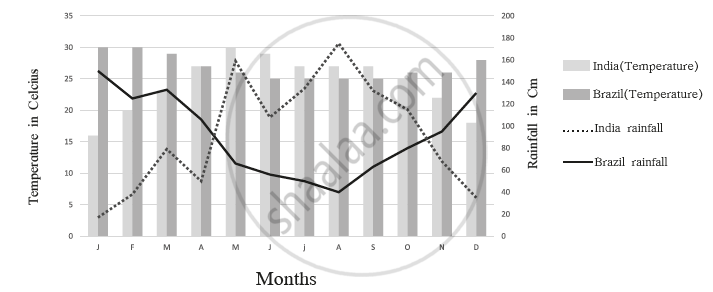
- What is the minimum and maximum temperature of India
- What difference do you find in the rainy period in Brazil and India?
- In which month does Brazil get less rainfall?
- In which month does India get higher rainfall?
- In which month does India get less rainfall?
- In which month does Brazil have a higher temperature?
Fill in the following in the given outline map, and also prepare an index.
- A state with high density in southern India
- The western coast
- Region with low rainfall in India
- The evergreen forest region in north-eastern India
- Hot desert
- State with one-horned rhinos
Find the odd man out :
With reference to flora of India :
The central location of India at the head of the Indian Ocean is considered of great significance. Why?
Both the countries have ______ type of government.
Considering hemisphere, which shape correctly represents the hemisphere in which India lies?
What do you know about the Purvanchal ranges?
Name the countries that form the India subcontinent.
What separates India from Sri Lanka?
Fill in the blank:
The __________ extend from Punjab in the west to the Brahmaputra Valley in the east.
The north-south extent of India is ______.
The Standard Meridian of India passes through Mirzapur, it is located in which state of India.
What is the southernmost part of India?
The 0° Meridian passes through Greenwich in ______.
Write the latitudinal and longitudinal extent of India.
Why do we need a Standard Meridian for India?
Show the following in the outline map of India with index.
- Thar desert
- Ladakh
- 0-20% urbanization state at the east of India
- Apple producing state at north most of India
- Chennai port
- Kanyakumari-a tourist centre
Collect information about the ‘Silk Route’. Also find out the new developments, which are improving communication routes in the regions of high altitude.
Mark the following in the outline map of India. Write the names and give the index.

- Indira Point
- River Ganga
- Chhota Nagpur Plateau
- Mawsynram
- High Population Zone
- Andaman and Nicobar Islands
