Do it yourself.
Advertisements
Advertisements
प्रश्न
Make a clay globe in your art class and mark the major latitudes and longitudes using the following colours. Blue, green, and brown.
एका वाक्यात उत्तर
Advertisements
उत्तर
shaalaa.com
या प्रश्नात किंवा उत्तरात काही त्रुटी आहे का?
APPEARS IN
संबंधित प्रश्न
Answer the following question in brief.
Name the features that are shown in blue, green, and brown colours on a map.
Name the line of latitude that divides the earth into the northern and southern hemispheres.
Fill in the blank
Roads, rail tracks, wells, etc. are ________ features on a map.
How would you recognize a metalled road and an unmetalled one on a topographical map?
Look at the symbols given here and answer the following question.
How do the features shown by these two symbols differ?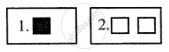
Symbols which help to show roadways and railways.
The ______ of a map describes the information given in the map.
In general, maps are drawn with ______ orientation.
The features of ______ colour in Map is agriculture.
The features of ______ colour in Map is Settlements, Road.
