Advertisements
Advertisements
प्रश्न
Describe the location of India.
Advertisements
उत्तर
India lies entirely in the northern and eastern hemispheres. It extends from 8°4’N to 37°6’N latitudes and 68°7’E to 97°25 ‘E longitudes. The Tropic of Cancer divides India into two parts by passing through it. The approximate area is 3.3 million sq km. The Himalayas separate it from the rest of Asia. It has many neighbouring countries with whom it makes a subcontinent. South of the Tropic of Cancer lies peninsular India-triangular mass of land projecting into the Indian Ocean. It is surrounded by water on three sides. The Arabian Sea in the west, the Bay of Bengal in the east, and the Indian Ocean in the south. The central position of India between the East and the West world has helped in the development of trade and commerce.
India at a Glance
Latitudinal extent: 8°4′ N – 37°6’ N
Longitudinal extent: 68°7’E – 97°25’E
Area : 32, 87, 263 sq. km
North-south extent: 3,214 km
East-west distance : 2,933 km
Length of the land frontier: 15,200 km
Length of coastline: 7,500 km
Number of states: 29
Number of union territories: 7
Capital: New Delhi
Total population (According to 2011 Census): 1.21 billion
Average population density: 382 persons per sq km
APPEARS IN
संबंधित प्रश्न
Read the following graph and answer the questions.
Temperature and Rainfall in Brazil and India
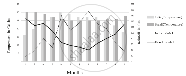
- What is the minimum and maximum temperature of India
- What difference do you find in the rainy period in Brazil and India?
- In which month does Brazil get less rainfall?
- In which month does India get higher rainfall?
- In which month does India get less rainfall?
- In which month does Brazil have a higher temperature?
Fill in the following in the given outline map, and also prepare an index.
- A state with high density in southern India
- The western coast
- Region with low rainfall in India
- The evergreen forest region in north-eastern India
- Hot desert
- State with one-horned rhinos
What separates India from Sri Lanka?
Which is the most of the volcanoes and earthquakes in the world located?
What is the soil of Bangar region that contains calcareous deposits locally known as?
What is the extent of the Northern plains of India?
Why do we need a Standard Meridian for India?
How India is politically divided?
Distinguish Between:
GMT and IST
India is located in the ______ hemispheres of the earth.
