Topics
Unit I Physical Environment
Locational Setting of India
- Locational Setting: Area, Latitudinal and Longitudinal Extent of India
- Importance of India's Location
- Comparison with China
- Comparison with Australia
- Overview of Locational Setting of India
Scales
- Conversion Between Statement of Scale and Representative Fraction (R.F.)
- Overview of Scales
- Construction of Graphical Scale
Representation of Relief
- Methods of Representing Relief on Maps
- Representation of Slopes by Contours
- Overview of Representation of Relief
Geological Evolution and Structure
- Geological History
- Difference between the Peninsular Plateaus and the Himalayan Mountains
- Geological Formations of India
- Overview of Geological Evolution and Structure
Unit II Population and Human Settlements
Unit III Resources of India and Their Utilisation
Relief
- The Himalayan Mountain Complex
- Western Himalayas VS Eastern Himalayas
- Regional Divisions of the Himalayas
- Significance of the Himalayas
- The Indus-Ganga-Brahmaputra Plain
- Comparison of Plains in Northern India
- Regional Divisions of the Plain
- Significance of the Plain
- Physical Division of India > The Peninsula
- Western Ghats VS Eastern Ghats
- Physical Division of India > The Peninsula
- Physical Division of India > The Coastal Plains
- Physical Division of India > The Island Group
- Overview of Relief
Study and Interpretation of Topographical Maps
- Topographical Maps
- Development of Topographical Maps in India
- Nomenclature and Numbering of Topographical Sheets
- Summary of Topo-Sheets Published by Survey of India
- Conventional Signs and Symbols used in Topographical Maps
- Interpretation of Topographical Maps
- Study and Interpretation of Some Selected Topographical Maps
- Transport
- Nature of Occupation
- Geographical Interpretation of Topographical Map Sheet No. 53H/3
- Overview of Study and Interpretation of Topographical Maps
Geographical Information System (GIS)
- Spatial Information Technology
- Components of GIS
- Spatial Data Formats
- Sequence of GIS Activities
- Overview of Geographical Information System (GIS)
Unit IV Infrastructural Resources
- Types of Transport > Railways
Drainage
- Evolution of the Indian River System
- The Himalayan River System
- The Peninsular Rivers
- Differences between the Himalayan and the Peninsular River Systems
- Overview of Drainage
Climate
- Factors Affecting India's Weather and Climate
- The Concept of Monsoon
- Mechanism of Monsoon
- Indian Monsoonal Regime
- The Rhythm of Seasons
- Annual Rainfall
- Incidence of Drought and Floods
- Temperature and Rainfall Graphs
- Overview of Climate
Unit V Regional Economic Development
Remote Sensing
- Introduction to Remote Sensing
- Electromagnetic Spectrum and Energy
- Zones of Remote Sensing
- Application of Remote Sensing in Geography
- Application of Remote Sensing in India
- Geology and Mineral Resources
- Overview of Remote Sensing
Surveying
- Concept of Surveying
- Types of Survey
- Plane Table Survey
- Methods of Plane Table Survey
- Advantages and Disadvantages of Plane Table Survey
- Overview of Surveying
Natural Vegetation
- Introduction of Natural Vegetation
- Major Types of Vegetation in India
- Impact of Human Activity on Vegetation
- Development of Forestry
- Forest Policy and Law
- Forest Conservation
- Overview of Natural Vegetation
Practical Work and Project Report
Population
- India's Population Compared with Other Major Countries
- Census of Population
- Distribution of Population in India
- Density of Population
- Index of Concentration
- Growth of Population: Basic Concepts
- Overview of Population
Project Work
- Importance of Field Work in Geography
- Outline or Planning for the Field Work
- Stages of Survey
- Overview of Project Work
Migration Trends
- Basic Concept of Migration Trends
- Types of Migration
- Out-Migration
- In-Migration
- Consequences of Migration
- Migration Streams
- Overview of Migration Trends
Demographic Attributes
- Concept of Demographic Attributes
- Rural-Urban Population
- Urbanisation in India
- Sex Composition
- Age Composition
- Literacy
- Working Population
- Occupation
- Overview of Demographic Attributes
Rural Settlements
- Settlments
- Types of Settlements
- Concept of Rural Settlements
- Factors Determining the Types of Rural Settlements
- Distribution of Rural Settlements in India
- Settlement Patterns in India
- Types and Patterns of Rural Settlements in India
- Overview of Rural Settlements
Urban Settlements
- Concept of Urban Settlements
- Factors Influencing Location and Growth of Urban Centres in India
- Problems Resulting from the Growth of Large Cities
- Urbanisation in India
- Metropolization (or Metropolitanization)
- Overview of Urban Settlements
Environmental Management and Land Use Pattern
- Need for Environmental Management Concerning Development
- Land Use Pattern in India
- Overview of Environmental Management and Land Use Pattern
Water Resources and Types of Irrigation
- Water Resources of India
- Water Demand and Utilisation
- Emerging Water Problems
- Conservation of Water Resources
- National Water Policy of India-2002
- Irrigation
- Means of Irrigation
- Primitive Methods
- Modern Methods
- Dangers of Overwatering
- Overview of Water Resources and Types of Irrigation
Agriculture
- Wet and Dry Agriculture
- Crop Rotation
- Crop Combination
- Cropping Intensity
- Problems of Indian Agriculture and Their Solution
- Uses of Technology in Agriculture (Modern Inputs)
- Scope of the Green Revolution
- Impact of the Green Revolution
- Demerits or Problems of the Green Revolution
- Suggestions For the Stability of the Green Revolution
- Crop Seasons
- Major Crops: Food Crops
- Major Crops: Commercial and Industrial Crops
- Market Gardening
- Overview of Agriculture
Fisheries
- Introduction to Fisheries
- Fish Production in India
- Marine Fisheries
- Fresh Water or Inland Fisheries
- Programme for the Development of Fisheries
- Fishing in Japan
- Fishing in Bangladesh
- Types of Fishing
- Fishing Grounds
- Fish Conservation
- Overview of Fisheries
Minerals and Power Resources
- Minerals
- Distribution of Minerals in India
- Metallic Minerals (Ferrous)
- Power Resources
- Conventional Sources of Energy
- Oil and Natural Gas
- Power Generation in India
- Nuclear Power
- Non-Conventional Sources of Energy
- Overview of Minerals and Power Resources
Transport and Communication
- Transport
- Types of Transport > Railways
- Types of Transport > Roadways
- Classification of Roads
- Water Transport
- Air Transport
- Pipelines
- Harbours and Ports
- Communication
- Personal Communication
- Telecommunication
- Geographic Information System (GIS)
- Mass Communication
- Importance of Infrastructure as Key to the Development of Industrial Economy
- Overview of Transport and Communication
Industries
- Introduction to Industries
- Types of Industries
- Industrial Clusters
- Factors Affecting The Location Of Industries
- Agro-Based Industries
- Agro-Based Industries > Sugar Industry
- Agro-Based Industries > Cotton Textile Industry
- Readymade Garments
- Mineral Based Industries
- Iron and Steel Industry
- Aluminium Smelting
- Cement Industry
- Transport Equipment
- Overview of Industries
Tourism Industry
- Concept of Tourism Industry
- Growth of Tourism in India
- Employment Opportunities in Tourism
- Places of Tourist Interest
- Tourism and Environment
- Overview of Tourism Industry
Regional Economic Development (Case Studies)
- Development: Meaning and Perspectives
- Multi-Level Planning
- Chhattisgarh Regions
- Electronics Industry in Bangaluru
- Growth of Haldia Port
- Overview of Regional Economic Development (Case Studies)
- Introduction
- State Level Analysis
Definition
Density of Population: The density of population is the number of persons living per unit of an area. It is usually expressed as number of people per square kilometre (sq km).
Formula
`"Density of population" = "Number of people in a defined area unit"/"Total area in square km of that particular area"`
Notes
The density of the Population in India
|
Note: Telangana became the 29th State of India in June 2014. |
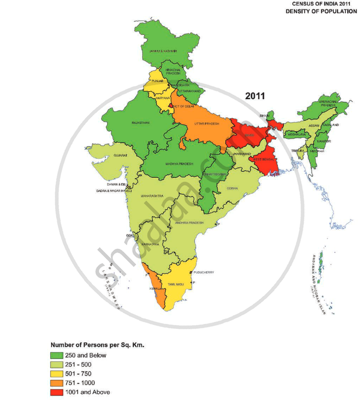
- The density of the population is the number of persons living per unit of an area. It is usually expressed as the number of people per square kilometre (sq km).
- According to 2011, the average population density of India is 382 persons per square kilometre. India is one of the world's ten most densely populated countries.
- Bihar is India's most densely populated state with a population density of 1,102 while Arunachal Pradesh has the least population density i.e. 17 persons per sq. km. Delhi is the most densely populated union territory, with 11,297 persons per square kilometre, while the Andaman and Nicobar Islands have the lowest population density.
- Rugged terrain and unfavourable climatic conditions are primarily responsible for states with population densities of less than 250 persons per square km.
- Assam and the majority of Peninsular states have moderate population densities. The terrain's hilly, dissected, and rocky nature, moderate to low rainfall, shallow and less fertile soils, and low population densities have all influenced population densities in these areas.
- Because of the flat plains with fertile soils and abundant rainfall, the northern plains and Kerala in the south have high to extremely high population densities.
- The states where less than 250 persons/km.sq lives are as follows:
1. Arunachal Pradesh
2. Chhattisgarh
3. Himachal Pradesh
4. Madhya Pradesh
5. Manipur
6. Meghalaya
7. Nagaland
8. Mizoram
9. Rajasthan
10. Sikkim
11. Uttarakhand - The three states of the Northern Plains with high population densities are:
1. Uttar Pradesh
2. Bihar
3. West Bengal
Example
Calculate the population density of the area shown in 1 sq.km, of square in ‘a’ and ‘b’ each.
 = 80 people = 80 people |
|
|
(a) |
(b) |


(a)
In fig. (a) there are 16 
Each  = 80 people
Total number of people = 16 × 80 = 1280
Fig. (a) has a population density of 1280 people per sq. km.
(b)
In fig. (b) there are 23
Each  = 80 people
Total number of people = 23 × 80 = 1840
Fig. (b) has a population density of 1840 people per sq. km.
