Please select a subject first
Advertisements
Advertisements
See the diagram and answer the following questions:

- Which rock layer has experienced the most weathering?
- Which rock layer has experienced the least weathering?
- What could be the reason behind the difference in weathering?
Concept: undefined >> undefined
The satellite images are given in figure A and B belong to the same location but a different timeline. Study the images and answer the following questions.

Figure A

Figure B
- Compare the images and tell what differences do you find in these images.
- In 2019 what does the patch of land going from north-west to south-east signify? Why was it not there in the 2011 image?
- To what extent is the climate of the place responsible for this disaster?
- Which other factors are responsible for the disaster?
Concept: undefined >> undefined
Advertisements
Study the following schematic diagram. It shows the relationship between the speed of material and moisture content. Read the index, and answer the following questions:

- Fast
- Slow
- Dry
- Wet
- Creep
- Slide
- Fall
- Flow
Question:
- What will happen when the weather conditions are dry?
- When will a flow occur?
- When will a creep occur?
- Now can you enumerate the factors which affect mass wasting?
Concept: undefined >> undefined
Think of the reason why landslides should be more frequent in the foothill zone of the Himalayas and Western Ghat region. Why do landslides not occur in Marathwada in Maharashtra or the Maidan area in Karnataka?
Concept: undefined >> undefined
Give a geographical reason:
One finds many sheep rocks, horns, aretes, and hanging valleys in the Himalayas.
Concept: undefined >> undefined
Distinguish between tributaries and distributaries.
Concept: undefined >> undefined
Answer in detail:
Explain how the depositional work done by river Ganga has been beneficial to human activities.
Concept: undefined >> undefined
The names of many places may have some relation with the landforms located there. The names of a few of them are given below as examples. You are expected to find out the particular landforms to which they are associated. Find about them and try to locate them on a map using an atlas. Make a list of similar examples from India. Discuss your findings in the class.
| Name of the place | Landform associated with the name | Location |
| Revdanda | Sand bar | Raigad, Maharashtra |
| Ganpati Pule | Beach | Ratnagiri, Maharashtra |
| Pravara Sangam | Confluence of rivers | Ahmadnagar, Maharashtra |
Concept: undefined >> undefined
Have you ever been to a river and seen its bed? Discuss in the class about your observations about the river, its banks, its bed, and its velocity.
Concept: undefined >> undefined
- What kind of activities will bring people from other regions to the ice cap climate?
- What could be the occupations followed in the ice cap climate?
Concept: undefined >> undefined
Use the Internet or reference books to find out about the attempts at classification of climates.
Concept: undefined >> undefined
Answer in detail:
Explain, with examples, the effect of latitude on a place’s climate.
Concept: undefined >> undefined
Answer in detail:
Explain the factors affecting the climate of a place giving examples.
Concept: undefined >> undefined
Identify the correct correlation:
A: Assertion; R: Reasoning
A: More deposition occurs in the continental slope.
R: The slope is steeper here.
Concept: undefined >> undefined
Identify the correct correlation :
A: Assertion; R: Reasoning
A: The islands are actually peaks of submerged mountains.
R: Some peaks of submerged mountains come above the sea level.
Concept: undefined >> undefined
Identify the correct correlation:
A: Assertion; R: Reasoning
A: The abyssal plains are the deepest parts of the ocean
R: They lie at the bottom of the ocean
Concept: undefined >> undefined
Give a geographical reason.
Fishing has developed on continental shelves.
Concept: undefined >> undefined
Give geographical reasons.
Our knowledge regarding the oceanic trenches is limited.
Concept: undefined >> undefined
Answer in detail:
There is a similarity in the relief on the land surface and the ocean bottom.
Concept: undefined >> undefined
Given below are the names of some ocean basins in the Indian Ocean. Identify these in figure Write a note on their locations, their separators, and the rivers entering into them. Rank these according to their size on the basis of your perception.
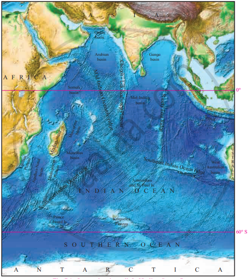
- Oman basin
- Arabian basin
- Somali basin
- Mauritius basin
- Mascarene basin
- Agulhas-Natal basin
- West Australian basin
- MidIndian basin
- Ganga basin
Concept: undefined >> undefined
