Advertisements
Advertisements
प्रश्न
Read the following map and answer the questions given below.
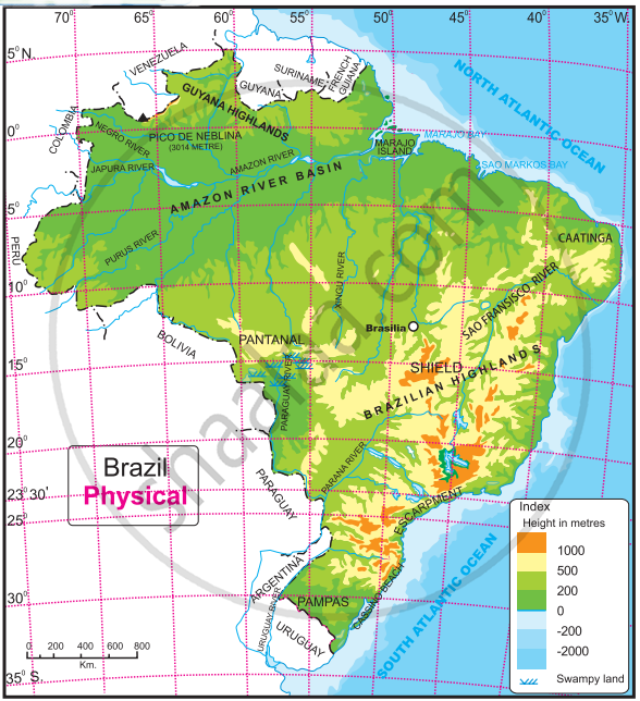
Questions-
- What is the range of the altitude of Amazon river basin?
- Between which two highlands is the Amazon river basin located?
- Write the height of the peak ‘Pico de Neblina’.
- Caatinga area is found at which direction of Brazil?
- Which grassland is located at south of Brazil?
Advertisements
उत्तर
- The range of the altitude of Amazon river basin is 0 meter to 200 meters.
- The Amazon river basin is located between Guyana Highlands in the north and Brazilian Highlands in the south.
- The height of the peak ‘Pico de Neblina’ is 3014 metres.
- Caatinga area is found at north-east direction of Brazil.
- 'Pampas’ grassland is located at south of Brazil.
संबंधित प्रश्न
The westernmost point of Brazil is ------------------------
Identify the correct correlation and make a chain.
| A | B | C |
| 1) Ganga river | i) Pau Brasil | a) trees shed their leaves |
| 2) Amazon river | ii) sediments deposit | b) there are islands at its mouth |
| 3) Brazil | iii) Teak trees | c) country named after it |
| 4) Deciduous forests | iv) no sediments | d) distributaries at the mouth |
Read the following map and answer the given questions.

1) Which method has been used to show distribution in this map ?
2) Name any one state in the north having low population
3) Name any one State/region with very dense population distribution
4) Comment upon the nature of population in the coastal region.
5) What is the nature of population in western Brazil.
6) Comment upon the trend of population distribution.
Explain about India and Brazil in terms of location, extent and their differences.
Is this sentence right or wrong? Rewrite the wrong ones.
The longitudinal extent of Brazil is less than India.
Is this sentence right or wrong? Rewrite the wrong ones.
Equator passes through the northern part of Brazil.
Which of the following shapes show the coastal part of Brazil correctly?
Considering the hemisphere, which correctly represents the hemisphere in which Brazil mainly lies?

Which country is called ‘the coffee pot of the world’?
Observe the map of Brazil and answer the following questions.

- Name the only port which may be considered inland.
- What are the modes of transport available from Brasilia?
- Name two tourist places with an airport and a port.
- What is the relative position of Cuiaba with respect to Brasilia?
- How can you reach Brasilia from Rio de Janeiro?
- Which is the tourist location in the extreme west?
