Advertisements
Advertisements
प्रश्न
How can the distribution of the height and landforms in a region be shown?
लघु उत्तरीय
Advertisements
उत्तर
- A variety of landform characteristics, such as altitude, relief, slope, slope direction, and drainage, must be taken into account when researching various landforms on Earth’s surface.
- Maps created with mathematical survey techniques are utilised for this.
- These maps help in our knowledge of the landforms’ stated features.
shaalaa.com
Contour Maps and Landforms
क्या इस प्रश्न या उत्तर में कोई त्रुटि है?
संबंधित प्रश्न
To whom are the contour maps useful?
What do you understand by observing contour lines?
How will a contour map be useful for a farmer?
If the contour lines are closer to each other, the slope is ______.
The contour lines on the map represent ______.
The slope can be understood from the distance between the ______.
If the distance between two contour lines is more, the ______ is gentle.
Identify the landforms in the following map.

Observe this model and the map figure a and b given below it and answer the following questions.
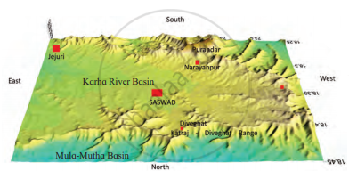

- In which direction does fort Purandar lie?
- What is the direction of the flow of the river Karha?
- In which parts are the hill ranges not observed?
- Which part of the map is not seen in the model? Why?
- In which direction does the altitude of the Katraj-Diveghat range decrease?
- In which direction are higher hill ranges located?
Observe the given figure and answer the following questions.
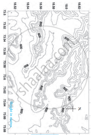
- What is the general direction of the ranges shown in the map?
- Towards which direction is the flat land located in the map?
- What are the maximum and minimum values of the lines in the map?
- What do these values indicate?
- Do you find any similarities in the map and the model in Figure? What are those?
- Which figure gives us more information and what is that information?
- Is there any similarity between this map and the sketch map of the potato hill?
- What all do you see in the map?
