Advertisements
Advertisements
Question
Study the transport map of Brazil in the figure and answer the following questions:
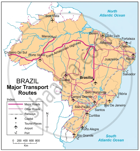
- Which means of transport are seen on the map?
- Which means of transport has a denser network?
- Which highway can be seen prominently? Which places does it join?
- What could be the reason of development of railways in the South-East?
- In which part of Brazil do you see a lesser development of transport network ? What could be the reason?
Advertisements
Solution
- All the means of transport, like roadways, railways, airways, and waterways, are seen on the map.
- The roadways have a denser network.
- The Trans Amazonian Highway can be seen prominently. It connects Cruzeiro do Sul, Porto Velho, Manaus, and Brasília.
- South-east Brazil is the richest and most populous region of the country. Agriculture, mining, and tourism are well developed in this part of Brazil.
- The reasons for the development of railways in the South-East are:
- Brazil’s natural environment, including the Amazon forest in the north and swampy plains, is not conducive to agriculture. Development of railways. This region has a minimal population.
- South-east Brazil’s fertile and accessible terrain allows for train links. This location is ideal for trade and business because of its proximity to popular tourist destinations, like Brasilia and Rio de Janeiro.
APPEARS IN
RELATED QUESTIONS
State whether it is right or wrong with reason.
The indicator of development in a country is the development of transport in that country.
What are the difficulties in the development of the railway system in Brazil’s internal areas?
Write notes on
Correlation between physiographic and internal waterways
Considering the development of transport in a place, which factors do you think are responsible for the development of transport in Brazil? Also, think which means of transport could be used in Brazil given its topography and drainage?
Distinguish Between
Transportation in India and Brazil
In which parts of Brazil less transportation routes are found?
Give geographical reason.
Waterways are developed in Brazil.
What is the condition of waterways as a mode of transport in India and Brazil?
Match the column:
| Column 'A' | Column 'B' | ||
| (1) | Trans-Amazonian Highway | (a) | Teak |
| (2) | Thorny and bush-type vegetation | (b) | Football |
| (3) | Plain region | (c) | Major Highways |
| (4) | Popular game of Brazil | (d) | Khejadi |
| (e) | Punjab | ||
| (f) | Cricket |
The most common method of transportation in Brazil is ______.
