Advertisements
Advertisements
Which region of Brazil receives rainfall throughout the year?
Concept: undefined >> undefined
Mark the following in the outline map of India. Write the names and give index.

- Nilgiri Mountains
- Lucknow
- Palk Strait
- Malabar Coast
- Satpura Range
- Chilka Lake
Concept: undefined >> undefined
Advertisements
Brazil gets rainfall from the ______ and the north-east trade winds.
Concept: undefined >> undefined
Answer in one sentence.
Which type of rainfall occurs because of the natural obstruction of the Himalayas?
Concept: undefined >> undefined
Mark the following in the outline map of India. Write the names and give index.

- New Delhi
- Shivalik Range
- Indira Point
- Malabar Coast
- Narmada River
- Gulf of Kutch
Concept: undefined >> undefined
Which plateau is considered the big storehouse of different minerals?
Concept: undefined >> undefined
What is the state of urbanisation in Brazil, and why is it concentrated near coastal areas?
Concept: undefined >> undefined
Write about agriculture and mining in India with context to the economy of India.
Concept: undefined >> undefined
Study the given figures and answer the following questions:

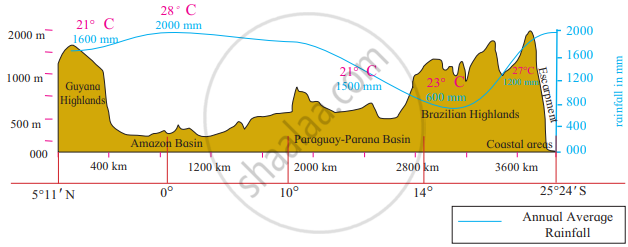
- Considering the isotherms of Brazil, what is the average range of temperature in Brazil?
- In which area does it rain more?
- From which directions are winds flowing towards Brazil?
- What could be the reason behind that?
- What could be the obstruction in the way of these winds?
- Which type of rainfall will occur because of these winds?
- Correlate these winds and rainfall.
- In which part of Brazil are the average temperatures low?
- Identify the rain-shadow area in Brazil. Describe its climatic characteristics.
- In which region do you find a higher temperature?
- Considering the latitudinal extent of Brazil, where will you find a temperate climate in Brazil?
- Describe the winds blowing between 0° to 5° N and S zones.
- Which method has been used to show distribution in this map?
Concept: undefined >> undefined
On the basis of the given figure, answer the following questions:
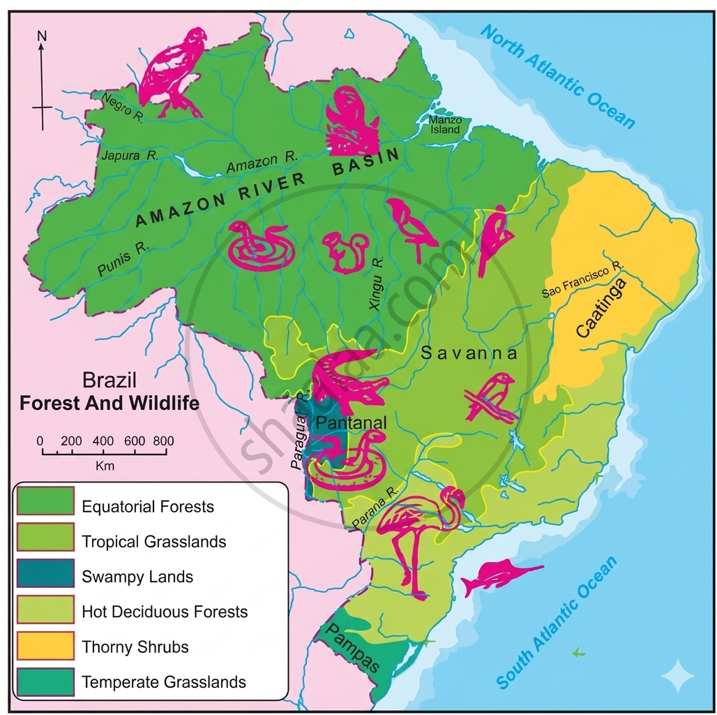
- Name the species shown on the map. Condor, Anaconda, Golden lion tamarin, macaw, etc,.
- In which regions are these animals found? Why are their habitats found in these forests?
- Classify the forest regions with reference to their extent.
Concept: undefined >> undefined
Study the choropleth map of Brazil showing the Statewise urban population of Brazil and answer the following questions.

- Which States (region) are the most urbanised?
- Which States (region) are the least urbanised?
Concept: undefined >> undefined
Which factors have affected urbanisation in Brazil?
Concept: undefined >> undefined
Obtain information regarding pisciculture in India with the help of internet and reference books and write a note.
Concept: undefined >> undefined
Show the distribution of crops like wheat, jowar, rice, cotton, sugarcane, tea and apple in the outline map of India. using symbols Name the map.
Concept: undefined >> undefined
Study the transport map of Brazil in the figure and answer the following questions:
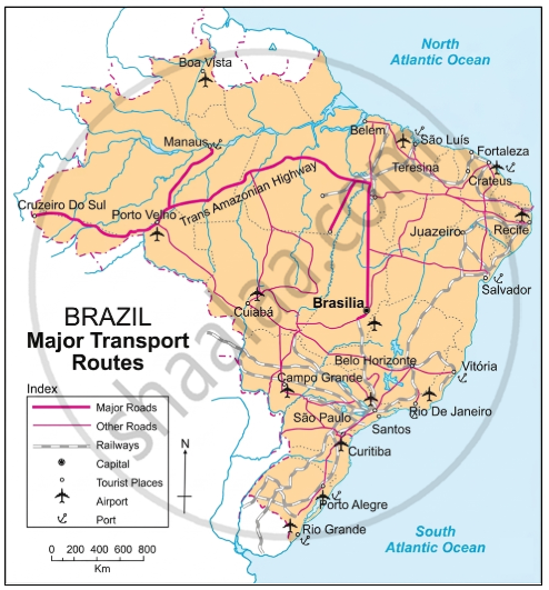
- Which means of transport are seen on the map?
- Which means of transport has a denser network?
- Which highway can be seen prominently? Which places does it join?
- What could be the reason of development of railways in the South-East?
- In which part of Brazil do you see a lesser development of transport network ? What could be the reason?
Concept: undefined >> undefined
Match the column:
| Column 'A' | Column 'B' | ||
| (1) | Trans-Amazonian Highway | (a) | Teak |
| (2) | Thorny and bush-type vegetation | (b) | Football |
| (3) | Plain region | (c) | Major Highways |
| (4) | Popular game of Brazil | (d) | Khejadi |
| (e) | Punjab | ||
| (f) | Cricket |
Concept: undefined >> undefined
Write short note:
Mining in india
Concept: undefined >> undefined
Match the columns :
| (a) | Evergreen Forests | (i) | Sundar trees |
| (b) | Deciduous Forests | (ii) | Pine |
| (c) | Coastal Forests | (iii) | Pau Brasil |
| (d) | Himalayan Forests | (iv) | Khejadi |
| (e) | Thorny and bush-type vegetation | (v) | Teak |
| (vi) | Orchid | ||
| (vii) | Sal | ||
Concept: undefined >> undefined
Find the odd one out.
With reference to fauna of Brazil:
Concept: undefined >> undefined
In the swampy areas of Pantanal ______ are found.
Concept: undefined >> undefined
