Advertisements
Advertisements
Give a geographical reason:
Temperatures are high in the pre-monsoon season in the equatorial region in the northern Indian ocean.
Concept: undefined >> undefined
1) Various biome regions have been shown on the map. Considering the latitudinal location, select the Mediterranean biome and write the name in its respective place in the index.
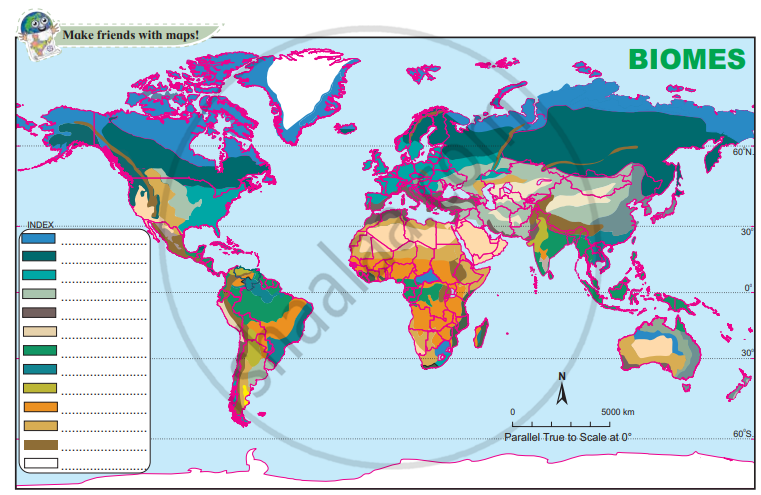
2) Write the names of the major countries that lie in the Mediterranean biome.
Concept: undefined >> undefined
Advertisements
Find out the names of countries that produce and export wheat and maize.
Concept: undefined >> undefined
Give geographical reasons:
Mediterranean biome has proved to be a catalyst for the development of the cinema industry.
Concept: undefined >> undefined
Write a short note on:
Marine biomes
Concept: undefined >> undefined
Fill in the blank with appropriate alternatives given below and rewrite the sentence.
Mediterranean forest is also known as____________ forests.
Concept: undefined >> undefined
Write in short:
Mitigation for cyclones
Concept: undefined >> undefined
Write in short:
Preparedness for floods
Concept: undefined >> undefined
Write in short:
Rehabilitation after earthquake
Concept: undefined >> undefined
Choose the correct alternative:
India has been successful in mitigating the effects of the following disaster:
Concept: undefined >> undefined
Why is disaster management called a cycle? See the figure given below.

Concept: undefined >> undefined
Why do people in Europe use olive oil for cooking?
Concept: undefined >> undefined
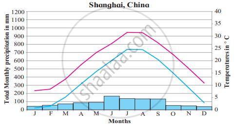
Read the graphs figure a and b and answer the following questions. Locate the places on the map:
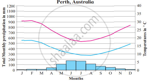
- Name the months of the highest rainfall.
- Name the months of lowest temperatures.
- Are the answers to 1 and 2 the same?
- Are the months of rainfall the same in both places? If not, why?
- What could be the factors which influence the climate of these places?
- What difference do you find between the previous and these graphs?
- Write a concluding statement about the climate of both places.
Concept: undefined >> undefined
Differentiate between Monsoon and Mediterranean Regions.
Concept: undefined >> undefined
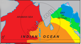
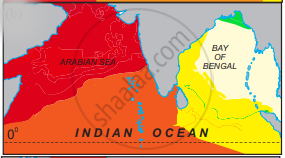
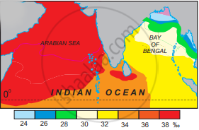
Given below are the maps depicting the salinity distribution of the northern Indian Ocean. Study the maps.
- NE monsoon,
- pre-SW monsoon
- SW monsoon
given in figure carefully and answer the following questions.
- Why does the Arabian Sea record higher salinity than the Bay of Bengal?
- What is the minimum salinity in the Bay of Bengal? In which seasons do we find it?
- Account for the high salinity in the Arabian Sea throughout the year?
Concept: undefined >> undefined
Give a geographical reason:
Salinity is less in the Bay of Bengal in the Indian Ocean.
Concept: undefined >> undefined
1) Various biome regions have been shown on the map. Considering the latitudinal location, select Temperate deciduous biome and write the name in its respective place in the index.
2) Write the names of the major countries that lie in the Temperate deciduous biome.
Concept: undefined >> undefined
In India, where do you find such fruits? What are the reasons for them being found here?
Concept: undefined >> undefined
What factors make humid subtropical climate agriculturally productive?
Concept: undefined >> undefined
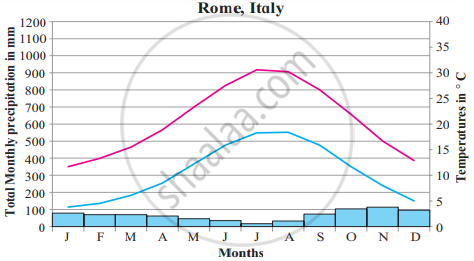
Read the graphs figure a and b and answer the following questions. Locate the places on the map:

- Name the months of highest and lowest rainfall.
- Name the months of highest and lowest temperatures. Relate them with rainfall months.
- Are the months of rainfall the same in both places? If not, why?
- What could be the factors which influence the climate of these places?
- What difference do you find between the previous and these graphs?
- Write a concluding statement about the climate of both places.
Concept: undefined >> undefined
